Deming, NM Loop Road Trip
March 30 to April 9, 2006
The Summary
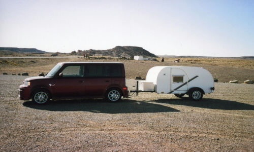
Miles with Pegasus (My Scion xB): 2,650
Miles with Pandora (My Teardrop)in tow: 2,600
Interstate Highway Miles: 117
Fuel Economy: 32.5mpg
Duration of the trip: 11 days
Nights in Pandora: 9
States Visited: 6
Teardrops in tow sightings: 5
Total Trip

30 March: Sparks to Beatty, NV

Roads: NV445, NV446, Nv447, US 95a & US 95
Distance: 346 miles
Camp: Bailey RV & Hot Mineral Baths
Route
I left Sparks via Pyramid Lake because I had never towed with the xB before and wanted some single lane roads before confronting Interstate traffic, I don't like Interstates and wanted to see the Lake again after some years. I stopped in Tonopah for gas and lunch and then checked out the RV park nearest Beatty - it looks like a "hobo camp". I turned around and went back to Baily RV and got a "no service" spot for $16.35. The spot was as advertised, simply a spot at the edge of the Park near the fence and a couple of rain puddles form the last two days of rain. I then unhitched and drove into Beatty for dinner at a Mexican Restaurant. It had been cloudy, windy and cold all day and stayed that way during the night.
31 March: Beatty to Las Vegas, NV
Roads: US95, NV374, CA190, State Line & Bell Vista Rd, NV160, NV 159 & Las Vegas Streets
Distance: 229 miles
Camp: Bob & Kay's
Route
It was very grey and overcast this morning but did not appear to have rained any during the night. I re-hitched and stopped at the same place for breakfast before proceeding into Death Valley. I had never been through the northern part of the Valley so took NV374 to see it. There was about 12 miles of dirt and mud because of construction on the road and a lot of water covering most of the Valley. I started seeing wild flowers along the roadside at about 2,500' elevation and greasewood bushes covered with their little yellow puff ball flowers at 2,000'. The winds were strong in the Valley but Furnace Creek Campground was full with more campers on the east side of the road in the very exposed and bare ground overflow parking. I also noticed that gas was $3.329 at the Furnace Creek Standard station but I didn't stop for any at that price. I then drove east through Furnace Creek to Death Valley Junction, CA and Pahrump, NV. Pahrump is a "sprawl city" that has gone crazy with growth - I can't think of any reason for it to exist except as a distant suburb to Las Vegas and the city "plan" is it's lack of one. The Red Rock Nature Conservation Area is very scenic but exactly at is boundary where NV159 becomes Charleston Street of Las Vegas it is all built up with a subdivision. While waiting for Bob & Kay (Peace Corps Volunteers with me in Bulgaria) to arrive at home I walked to Lou's Dinner for soup & sandwich lunch. After Bob and Kay got home we went out to a Bulgarian Restaurant where I had a traditional Zlatograd meal with a Zagorka beer - my first since 1998. A lot of visiting during the afternoon and evening.
1 April: Henderson, NV
Roads: Las Vegas Streets
Distance: Included above
Camp: Sam's Town RV
Route
After breakfast by Kay and more visiting I left for a Scion xB Club meet. I had been in contact with the Las Vegas Club via their Internet web site and message board and they had scheduled a meet that I could attend. Most of their meets had been held in the late afternoon but this one was set for 2:00 pm and in a location close to where I was going to stay for the night. I arrived at the Flamingo & Boulder Hwy location and by 2:30 there were 5-6 of us gathered to admire our cars. My towing a Teardrop was a hit and we drew a lot of attention as we "cruised" Flamingo Rd. to the Strip and then north on Valley View Blvd near where I had turned earlier in the day to reach the meet location. There we stopped at an auto parts store that was making a video of local cars. I didn't stick around to become a part of the video but I did receive a xB model from one of the Club members that matched my Salsa Red color; a just released color by Scion for their 2006.5 models.
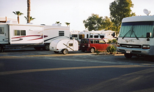
My 'rig' caused a few chuckles parked between these two monsters.
Drove back across town to Sam's Town RV where I was parked between two motor homes that had to be 40' each. As I was lying down in my Teardrop resting I could hear people walking by and their laughing at how funny my Teardrop looked between these two Goliaths. I had a good Mexican dinner in the Casino and a good nights sleep.
2 April: Henderson, NV to Mesa, AZ

Roads: Boulder Hwy, US93, I-40, US93, US60, AZ101, I-10, US60 & Mesa Streets
Distance: 308 miles
Camp: Mesa RV & Mobile Home Park
Route
This was the first time I had been on US93 since sometime in the 1970s and it has been widened and straightened a lot from what I remembered but the construction continues. Getting around metro Phoenix was easier than I expected but an accident with a death closed Apache Junction Freeway/US60 and I did a lot more street driving than I had planned on. This also found me getting to the RV Park a little latter than I wanted but it didn't make much difference there was no shade anyplace and it was now HOT - not that mid-80s is all that hot but after coming from Reno's 50s it did feel so. I called Jessica (Peace Corps Volunteer with me in Bulgaria) and left her a message that I had made it to town then went next door to a little "home style" restaurant for dinner.
3 April: Mesa, AZ
Roads: Mesa Streets
Distance: Included above
Camp: Mesa RV & Mobile Home Park
I unhitched this morning after breakfast next door and then drove toward west Mesa looking for Wild West Mercantile. While on the way I called Jessica again and got her on a cell phone that was like most of them when used indoors - bad reception. I called her again after a few minutes to allow her to get outside for better reception. I had thought she was living in Mesa but it turned out that she was in Phoenix but needed to come to Mesa on an errand so we agreed to meet at Red Robin on Stapley & US60. I then proceeded to Wild West Mercantile where I shopped the aisles for a little while before meeting her for lunch. The lunch with visiting took us over 2 hours - lots of catching up to do.
4 April: Mesa to Douglas, AZ
Roads: Mesa Streets, US60, AZ79, AZ77, I-10, AZ80, Davis Rd, US191 & Douglas Streets
Distance: 235 miles
Camp: Douglas Municipal Golf Course
Route
I re-hitched and got an early start this morning; didn't see a possible breakfast stop until spotting a truck stop east of Tucson. I stopped again in Tombstone to walk up and down Allen St., something I had not done for over 40 years. I remember going to Helldarado Days while in grade school or perhaps Junior High but had not been in Tombstone since then - I had driven through it many times but had never stopped. The best that I remember the streets were paved back then but now the "downtown" area has been "restored" to wooden sidewalks and dirt streets once again. I also stopped at San Pedro Saddlery and talked to Big Ed about a holster that I had ordered and not received. He promised again that it would be finished in 4 weeks but I have heard that once before and don't believe he can/will do it on time. I had originally thought I would stay in Tombstone overnight but it was still early in the day so I decided to drive on to Douglas. Last year I planned all my camping stops and made reservations for most of them, this trip I only reserved a spot in Las Vegas and Mesa. There is a lot more freedom in travel without making reservation but you also have to be mentally prepared to make adjustments if you find your first choice full. I unhitched once I was camped and spent some time driving around Douglas; stopping at the High School and downtown to look around. I drove through Douglas (where I graduated from high school) in 1996 on a prior trip but that time I drove around Sulfur Springs Valley to places where I had lived. The town is almost unchanged considering the many years that have passed; it was always a Mexican/American town since it is divided from Agua Prieta, MX only by a barbed wire fence. However, it now seemed to me to be a Mexican/Mexican town as if the fence had already come down. This is one of the border areas that has had a LOT of illegal immigration problems, and has had them for many years - my parents moved away from the area in the late 1970s because of the crime problems that the illegals brought with them.
5 April: Douglas, AZ to Sliver City, NM

Roads: Douglas Streets, AZ80, NM80, NM9, NM11, US180 & Silver City Streets
Distance: 252 miles
Camp: Rose Valley RV Ranch
Route
I re-hitched and left without breakfast intending to stop somewhere along the way. I made a great choice when I stopped in Rodeo, NM at the General Store and had some Hevoes Rancharos New Mexico style, that's with a lot of green chili. There was a strong wind from the west that gave me a push all the way to Columbus, NM (the town attacked by Pancho Villa) where I turned south to the Mexican border town of Palomas. I parked on the US side and walked across to see what bus transportation was available from here to the rest of Mexico. You can get a bus at the town Plaza that will take you further south but they are the converted school/"chicken bus" type transport. There are also some relatively modern vans that provide service to the south but they do not operate on any kind of fixed schedule - leave when they get a van full of passengers. Downtown Palomas is mostly drug stores, eye glasses and dentists with a few tourist shops and bars. I started north toward Deming, where I had originally planned to stay the night, just as the wind was increasing even more and started to blow dust across the road. I had wanted to come to Deming to see if it was someplace that I might want to live for 1/2 the year and 1/2 in Mexico. The valley where Deming is placed is very wide and reminds me somewhat of the Central Valley of California - distant mountains, farm fields but much dryer. The blowing wind and dust put a cap on my not liking the place and I drove on through toward Silver City. I was perhaps 20 miles north of Deming when I heard a radio announcement that ALL roads into town had been closed because of blowing dust. By the time I got to Silver City I was getting some scattered showers. I did get parked, unhitched and drove into "old town" where art galleries are separated by antique shops for a chili reyanos dinner then back to camp for the night and more rain.
6 April: Sliver City to Gallup, NM
Roads: US180, US191, AZ61/NM53, NM602 & Gallup Streets
Distance: 272 miles
Camp: USA RV Park
Route
I re-hitched, had breakfast on the way out of town and started a series of climbs for the day. A lot of short climbs and 3 longer ones with the first pass at 6,500' and some light snow from last nights storm. The second and third were at 8,000' east and 8,550' north of Alpine, AZ with probably 2" of new snow. Then all of the country from Alpine to Gallup, NM had some light snow. It was still quite windy but mostly a tail wind with the temperature staying rather cool in the mid 50s. Nothing much happening in Gallup with the cold wind blowing except unhitch, shower and go out for pizza. Got in bed early to snuggle up in my sleeping bag for the night.
7 April: Gallup, NM to Page, AZ
Roads: US491, US64, US160, CO41/UT162, US191, US163, US160, AZ98 & Page Streets
Distance: 339 miles
Camp: Lake Powell Campground
Route
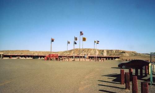
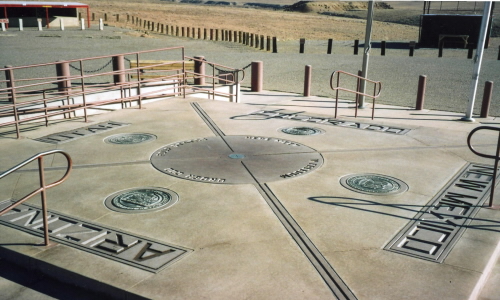
 The first picture is the Four Corners Monument with all the state flags flying plus some. Directly behind the Monument is a long low shed type structure that has multiple booths for the Indians to sell 'stuff'. The second one is the actual marker where the four states (AZ, NM, CO & UT) meet. I heard a report of the radio that the National Geologic Survey has determined that the marker is in the wrong place, didn't hear what was going to be done about it if anything. Then a couple of shots of Pegasus/SHOOBOX and Pandora/DASHOO with the four corners landscape as a background.
It was still cold this morning when I re-hitched and got out of town. It was also VERY cold and windy at 4 Corners were I stopped briefly to great a couple of pictures. The Indians collect an entrance fee to the 4 Corners Monument, which I don't begrudge them, but they have destroyed the scenic beauty around the Monument with over 25 booths that are selling "Indian stuff". I stopped for a late breakfast at a Trading Post/Cafe the was right before a bridge across the San Juan River. Then proceeded north and west before turning south through Monument Valley. All of that area from 4 Corners to Monument Valley is covered with mesas, canyons, dry washes and rock formations that impressed me more than what can be seen of Monument Valley from the highway. This country does have a lot of short and very steep climbs that had me gearing down and going slow. When I got to Page I found 5 Teardrops at the campground, they were at the 1st Annual ITG last year when I first saw them. All 5 of the trails are built the same and belong to family and friends and are known as the Five Wide Club because they are 5'x10' vs. the usual 4'x8'. They had come together for a week's vacation to see Lake Powell and the area around the lake. I unhitched and drove into Page for dinner and then joined the Five Wide Club for drinks and teardrop talk at camp until well past my bed time - it has been much warmer today and we could sit outside comfortably.
8 April: Page, AZ to Tonopah, NV
Roads: US89, UT14, UT130/56, NV319, US93, NV375, US6 & US95
Distance: 434 miles
Camp: Ramada Inn
Route
I was up and re-hitched early in the morning with the intent to stop along the way for breakfast. As is worked out I had to wait until Cedar City, UT at the Market Cafe on UT56 but was worth the wait. It also allowed me to drive UT14 early in the day before there was much traffic. It was a beautiful section of the trip with 3-4' of snow along the road and some meadows high in the mountains hosting early morning snowmobile riders. There were a few short steep climbs but the xB took all in stride to the summit at 9,910'.
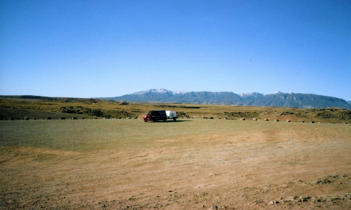
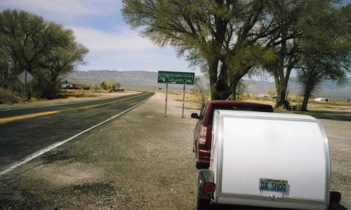 This is the eastern end of The Extraterrestrial Highway, I had been across it once before from the west when I went to Las Vegas in my MINI.
I encountered strong side and head winds from Cedar City to Rachel, NV and decided to press on to Tonapah for the day. The only place to camp in Rachel is a very exposed field near the Little A'le'Inn about midway on NV375 (The Extraterrestrial Highway). By going to Tonopah I was able to get out of the wind, get a room with a shower and could walk downstairs to dinner. I also shortened up tomorrows drive back to Sparks, avoid some afternoon traffic, get the trailer parked and car unloaded.
9 April: Tonopah to Sparks, NV
Roads: US95, US95a & I-80
Distance: 234 miles
Camp: Home
Route
Nothing much to say about this final drive of the trip, was simply get home. I had planned on an early spring trip with the idea that there would be wild flowers along the way but it has been a late spring all over the west after a reasonably wet/snowy winter. No wild flowers except in the lower levels of Death Valley and a few in the lower elevations of Arizona. That was my only disappointment of the trip. The Scion xB worked very well as a tow vehicle, with a little less power I need to shift more/earlier but it did everything I asked of it. Now to sit and dream of future trips!