International Teardrop Gathering 2007
April 11 to July 7, 2007
The Summary
Miles with Pegasus (My Scion xB): 11,94
Miles with Pandora (My Teardrop) in tow: 10,841
Interstate Highway Miles: 441
Fuel Economy: 33.3mpg
Duration of the trip: 88 days
Nights in Pandora: 64
States Visited: 29
Teardrops in tow sightings: None
Total Trip

11 April: Sparks, NV to Delta, UT

Roads: I-80, US50a, & US 50
Distance: 458 miles
Camp: Antalope Valley RV Park
Route
Today I was on US50 across NV, "The Loneliest Highway in America", passing through Fernly, Fallon, Austin, Eureka, Ely, NV to Delta, UT. The difference between this trip across NV on US50 vs two years ago to my first ITG is startling. I remember TALL green grass back then, this year it is a very stark dry desert. I also remember rain 2 years ago whereas this year it is light snow. There was a forecast of rain/snow in Reno this morning and I got out of town just ahead of snow in north Reno/Stead around 8:00am. I was going to stay at the Prospector Casino RV Park in Ely but found out that it didn't have showers. When I came out of the RV office it was starting a snow shower and the wind had increased. It was then that I decided to go on to Delta, UT and avoid having two passes covered with snow by tomorrow morning. That made it a long day but I had planned on a long day tomorrow so it should all balance out. That is one of the benefits of not making firm plans and/or reservations on this trip - I'm on a far more flexible schedule this trip than in the past. I started my TAB (Tour Around Bulgaria) on April 11, 1998 and have started this one 9 years later; a great way to celebrate ones birthday in my opinion!
12 April: Delta, UT to Montrose, CO

Roads: US50, US50/I-15, US50, US50/I-70, US50 & US550
Distance: 351 miles
Camp: Wal*Mart
Route
My travels today were again on US50 that took me through Scipio and Salina, UT plus Grand Junction, Delta to Montrose, CO. Today was also my longest day of Interstate driving - US50 and I-70 is the same highway across the eastern part of Utah and left me no choice if I was to follow US50. I do not drive Interstate highways if I can find another route that will get me to the same destination even if it might be somewhat longer. In the case of I-70 across Utah there are few alternatives that I have not been on before. Therefore I was on I-70 and was pleasantly surprised. Most Interstate driving is boring as hell and you see nothing but I-70 from Salina, UT to Grand Junction, CO is quite scenic and a great drive. I had snow showers and light rain on and off during the morning but not enough to spoil the views. I stopped in the Delta, CO Sheriff Office and checked on US50 road conditions and found that chains were required between Montrose and Salida, CO. I had originally planned on staying in Delta but decided to continue on to Montrose. When I got there I checked in with the Sheriff Office again and found that US50 was open to all traffic except trucks. I then went to Wal*Mart and inquired about staying in their parking lot for the night and got an OK. The manager also told me that if I got an early start and made it over Monarch Pass before noon that I wouldn't have any problems. So that's the plan!
13 April: Montrose, CO to Garden City, KS

Roads: US550 & US50
Distance: 437 miles
Camp: Garden City Travel Plaza
Route
My travels today were all on US50 through Gunnison, Salida, Canon City, Pueblo, La Junta and Lamar, CO finishing in Garden City, KS. It was sprinkling very lightly this morning but by the time I reached the base of Monarch Pass it had changed to snow showers. The pass required chains for trucks but not for cars; if it had been US 50 in CA there would have been mandatory chains for everyone. The west side of the pass was plowed well, the east side had enough packed snow on the road that it looked like a toboggan chute. I was in light snow fall from the summit, 11,312 feet, until almost Lamar, CO where it cleared.
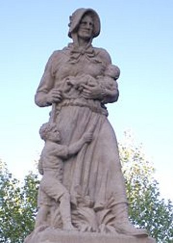 In hindsight, I should have stopped in Lamar where there is one of the Madonna of the Trail statues. I have now been in every town west of the Mississippi that has a Madonna (except Albuquerque) but have not seen any east of the Mississippi. That may be one of my future trip ideas, follow the trail of Madonnas across the USA. However, I decided to go to Garden City, KS - a bad decision. There was lots of blowing snow across the highway in KS and it was not well plowed. From Syracuse to Lakin it was hardly plowed at all, only one lane and that was two tracks with a high hump of snow between them. There were also spin out all along the roadway. I got behind an 18 wheeler and tried to stay close and in its tracks but the trailer was empty and the wind was pushing it from side to side throwing snow into the tracks. I finally got to a gas station/truck stop near Garden City. Got out of the car to fill up with gas and promptly slipped in snow/ice/slush and hit my right elbow on something. While I was paying for the gas I discovered that I had pealed a large portion of skin off my elbow and was bleeding badly. I went to the restroom and got my jacket cleaned up and then begged a bandage from the cashier. Parked in the restaurant parking lot for the night which was covered with 8-12" of snow but was quieter than parking with the diesel trucks running all night.
14 April: Garden City, KS to Nevada, MO

Roads: US50, US50/I-35, US50, KS99 & US54
Distance: 422 miles
Camp: Wal*Mart
Route
My route took me through Dodge City, Hutchinson, Newton, Emporia, and Fort Scott, KS to Nevada, MO. The exciting portion of the day was getting out of the parking lot in the morning. I was in snow that now had a frozen sheet of ice underneath it or just ice in the tire tracks. I couldn't get any traction and went to the Truck Stop staff for some help. With a staff person digging and my jacking back and forth I finally got into some fresh tracks and got onto the highway. It was then clear roads for the rest of the day but I saw snow and spinouts in the ditch all the way east to Emporia. I don't know how I managed yesterday - it was terrible. The road would have been CLOSED if it had been NV or CA. I also saw no vehicles with chains, absolutely NONE. (I found out later that chains are not legal in KS which accounts for me not seeing any and also accounts for the large number of spinouts in the ditch.) When I got to Nevada, MO I was only about 70 miles for Clinton, MO (the southern terminal to the Katy Trail) but did enough miles for the day and it was later than I thought because of another Time Zone change.
15 April: Nevada to Jefferson City, MO
Roads: US54, MO13, MO52, MO127, County B, US65, US50, US65, County HH, MO135, I-70, MO5, US40, County J, O & K, MO163, County N, US63, US54 & US Bus50
Distance: 263 miles
Camp: Wal*Mart
Route
A note on the pronunciation of Nevada, MO: The state where I live is Nu Va Du (the Va like in vat) the town in MO is Nu VA Du (the VA like in invade). My route today had me driving the 1st half of my planned hike of The Katy Trail that starts in Clinton, MO. I stopped in the Clinton Square this morning and then checked for a camp site near the trail head. The driving route then took me to each of my scheduled stops along the Katy Trail (they can all be read about at the link shown above) where I checked for camping or food availability: Windsor, Sedalia, Clifton City, Pilot Grove, New Franklin, Huntsdale & Hartsburg. A lot of driving for about 110 miles of trail. I also crossed the Missouri River twice today on the Boonslick Bridge (Boonville) & Jefferson City Bridge, I'll try and keep track of my crossings as I go along. I found a problem with my plan to leave my car in St. Charles and have a B & B shuttle me to Kirkwood to catch Amtrak. The train leaves at 6:29 am or about 4:30 pm - neither time is very good. So I'm now thinking I'll drive back to Clinton and leave my car and trailer there. Then when I finish hiking the Trail on May 1st I can get a shuttle to Amtrak on the 2nd at 4:30 pm, overnight in Sedalia, shuttle to Clinton on the 3rd. I'll then leave from there toward Cedar Falls, IA and the Krebs to arrive on the 4th.
16 April: Jefferson City to O'Fallon, MO
Roads: US Bus50, US54, MO94, City Streets, MO94, I-70 & County K
Distance: 132 miles
Camp: Wal*Mart
Route
My route took me through a driving route of the 2nd half of my planned hike of the Katy Trail with stops in Tebbetts, Rhineland Dutzow, Weldon Spring & St. Charles and then part of my backtrack to Clinton. I did the same camping and food inquiries but had a much easier time of driving the second half - all on MO94 and the Jefferson City Bridge again (crossing #3). However, at about 1/2 of my stops there was no one around to answer my questions. There was a note at the Rhineland/Bluffton, MO campgrounds that they would not open until May 5th. I'm planning on stopping there anyway and will just see what happens - there is no other good camp alternative. When I got to St. Charles the Lococo House B & B owners were not at home either but I waited about 45 minutes for them to return. The new plan for leaving from Clinton and having them shuttle me on May 2nd is better for them also. I then called and met with Dan "Danimal" from the 1990 Cycle America bike ride across the country. We sat in the Wal*Mart parking lot and traded remembrances for about 2 hours. It was great to see him again after 17 years. He also has cut his bike riding down to very little compared to my none.
17 April: O'Fallon to Sedalia, MO
Roads: County K, I-70, US65 & US50
Distance: 160 miles
Camp: Wal*Mart
Route
Took the fastest way back to Sedalia which was I-70, don't drive Interstates much but they do serve a purpose (interesting scenery isn't one of them). It also let me cross the Missouri for the 4th time on the Rocheport I-70 Bridge. Before I left O'Fallon I went to the library to use the Internet (they charged me $2, the ONLY library to do so). I tried to get an online ticket with Amtrak but the only option was to have them mail me the ticket - NOT an option as far as I was concerned. When I got to Sedalia I reserved a hotel room for May 2nd and tried to get a ticket from Amtrak via telephone. Once again I was thwarted by their rules. I couldn't order a ticket more than 3 days before I was going to travel and have it held by the conductor. I guess I'll try again when I get to St. Charles on May 1st. If anyone is wondering why Amtrak isn't making any money they might look at their RULES concerning ticket purchases - they seem to do everything they can to not sell you a ticket. The only stations in the state of MO that sell tickets are Kansas City and St. Louis.
18 April: Sedalia to Clinton, MO
Roads: US50, MO65 & MO52
Distance: 40 miles
Camp: Clinton Community Center
Route
This was a very short day on the road to the Clinton Community Center where I will leave my car and trailer. It is about a 1/4 mile from the Center to the trail head and the Center has "hosted" Katy Trail bicyclist and hikers for a number of years. They allow tents to be set up or in my case I was allowed to sleep in my trailer in the parking lot, the Center's bathrooms and showers are available from early morning to late at night. I got my pack organized and put up my Contrail Tarptent for the first time. The instructions say that it will take 2 minutes "when you get the hang of it". I didn't get the hang of it the first time but most likely will improve daily with practice as I proceed east (maybe 2 minutes when I finish). I went to a Mexican restaurant that I had passed when I first came into Clinton from the south, on the south side of town - it wasn't very good.
Katy Trail Hike
19 April: Clinton to Windsor, MO
Hiking Katy Trail
Distance: 18 miles
Camp: Tent-Farrington Park
Route
I have five days of food with me and 48/32/16 oz containers full of water; used 64 oz and refilled at my first opportunity. I probably didn't need to refill but as it turned out my campsite was dry. I had stopped in Windsor yesterday and talked to the campground Mgr and he had said that I could camp near the bathrooms which would be open and water would be on. Neither was true! Therefore, to arrive in camp with all my containers full was a good thing. With all that said - the pack weight plus some bad judgment on my part made today's hike VERY tough. I thought I could walk the 9 miles to Calhoun like one of my training hikes and did not eat any breakfast (normal for training). Well I bonked at about the 7 mile mark and was sick by the time I got some food in me at Calhoun. The 7.5 miles to Windsor was about the same and I didn't feel well until I ate some dinner in town. I WILL have breakfast tomorrow in town before I get back on the Trail.
20 April: Windsor to Sedalia, MO
Hiking Katy Trail
Distance: 19 miles
Camp: Bothwell Hotel
Route
This was another tough day. The breakfast helped but I still was exhausted by the end of the day, that was 17.5 trail miles and 1.5 miles getting from camp to breakfast and to the trail.
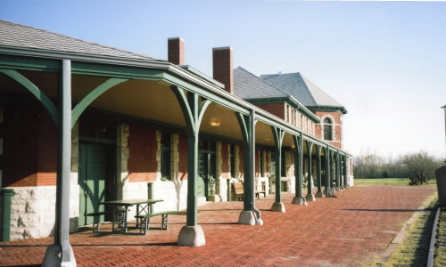 This may be considered a relic; it is the restored depot in Sedalia, MO where it now serves as a museum for the Katy Railroad and Information Center for the Katy Trail.
I made it to Sedalia but was at the southwestern Equestrian Trailhead and about 3 miles from the Hotel. Called a taxi for that last 3 miles! I had stopped at Green River for a sandwich and juice plus took time to lance a blister on my right big toe. Then after another 4 miles I looked at the left big toe and it was forming a blister also so taped that one up. I have shorter hikes tomorrow and the 2 days after that - hope I can "heal up" in those 3 days. The Bothwell is a very nice restored Victorian in a very dead downtown Sedalia. The downtown area is a ghost town most of the time but certainly gives that impression on a Sat morning. Historical Note: Sedalia was the first trailhead for the legendary cattle drives from Texas after the Civil War. Also, Sedalia, Missouri was Scott Joplin's home for only a few years, but it is with good reason that Sedalia has become central to the Joplin story and the site of the annual Scott Joplin Ragtime Festival.
21 April: Sedalia to Clifton City, MO
Hiking Katy Trail
Distance: 12 miles
Camp: Tent-Pentecostal Church
Route
I slept in as late as I could to take advantage of the real bed, a very nice bathroom and the shorter miles that I had before me. The scenery changed around 1/2 way to Clinton City with a few hills and the Trail following Shaver Creek along the hill contours with an occasional cut in the hillside. I arrived at Clinton City and it was as dead/quiet as it had been on Sunday when I first stopped there. Neither time did I see anyone outside - but, it is a really small place. I knocked on a door to ask for permission to camp behind the Pentecostal Church which offered a perfect campsite. It was some 50 yards from the trail but had the advantage of its own Port-a-Potty. I got the OK from two different women, one said that she had attended the church, plus she allowed me to use a water faucet in her yard to fill all my containers. I rested during the afternoon and doctored 2 new blisters as well as the 2 old ones. I cooked up a dinner around 5:00, saving some of it for breakfast and was asleep before dark.
22 April: Clinton City to Pilot Grove, MO
Hiking Katy Trail
Distance: 13 miles
Camp: Tent-City Park
Route
Today's scenery and hike was much like yesterdays with blisters an ongoing problem. When I got to the Pilot Grove trailhead and General Market I bought a roll of 1" wide adhesive tape to see if it will work better than the narrow tape that I've been using. The largest blister on left big toe has broken and feels better, the one that I lanced is still painful both walking and when at rest. I called the Chief of Police and told him that I was in town and would be camping at the Park - this seems to work as far as getting approval is concerned. Pilot Grove on a Sunday is a bit more active than Clinton City was on Sat; I did see a few people about but then Pilot Grove is bigger (over 1,000 people). I got pizza from Casey's (like a 7-11) for dinner and will get sausage/egg sandwich, apple fritter and coffee for breakfast. Casey's and the General Market are the only places open on Sun or before 8:00 am. I had a strong wind all night and had a tough time keeping tent stakes in the ground until I got in the tent. I then had disrupted sleep because the tent sides were flapping against me and I was worried about when was the whole thing going to come down on me.
23 April: Pilot Grove to New Franklin, MO
Hiking Katy Trail
Distance: 14 miles
Camp: Tent-Katy Roundhouse
Route
Today's distance was only a bit longer but was even more painful; once I have walked a bit it is bearable but the first few steps are really hard to take. I arrived at Katy Roundhouse and found no one around and the bathroom/shower was locked. I had stopped and talked to the owner on Apr 15th and told him I would be hiking and he said I just camp anywhere. He emphasized the fact that the bathrooms/showers were always kept clean and with hot water. NOTHING said about them being locked! I had picked up 2 sandwiches at Snoddy's (just north of the Boonslick Bridge that I hiked this time for Missouri River crossing #5.) for dinner and breakfast. I had just finished cooking a Lipton Side and was starting to eat it and one of the sandwiches when the owner came around to collect the camp fee and I got the code to the bathroom/shower, He had not checked his voice mail where I had left a HELP ME message some 3 hours earlier. I had also called a Shuttle Service to come and get me tomorrow morning. When I had got me tent set up I pulled off my boots to do some more doctoring and found that I had blood under 3 toenails and will probably loose 2 toenails (end result was 4 black and lost 3). I had scheduled 17 and 18 mile hikes for the next 2 days and with my feet in this shape I knew that I would never be able to do them. I'm done!
24 April: New Franklin to Clinton, MO
Shuttle Service
Distance: None
Camp: Clinton Community Center
The Shuttle driver was to pick me up at 10:00 but showed up a little after 9:00 am. The driver/owner was a "talker" and wanted to give me the usual guided tour of all the towns and roads that I had already seen between New Franklin and Clinton. I also added Missouri River crossing #6 on the Boonslick Bridge again. Therefore, it took about 4 hours to get back to Clinton with stops for breakfast, gas, ATM and a milk shake in Windsor at the smallest Dairy Queen I have ever seen. I unloaded my pack and stowed everything in my car except for my hiking shirt and pants that probably would not have lasted the hike - they went in the trash. I then had a great Mexican lunch/dinner at El Camino Real ("the" Mexican restaurant in town). Then for the evenings entertainment I got a very hard rain with thunder and lots of lightning. The trail leaked once again around the hatch hinge but I wedged a scrubby sponge in place and with a few squeeze dry replacements that seems to control the water damage. Even with the leak I was VERY happy to be in the trailer, if I had been in my tent I'm afraid it would have been and even wetter evening. A lot of closed roads in the Kansas City area and flooding in parts of MO because of this storm. My shuttle driver recommended a couple of routes to Cedar Falls, IA and I'll probably take his suggested "up the Mississippi River".
25 April: Clinton, MO to Wood River, IL

Roads: MO13, US50, US50/I-44, US 50, US50/I-255, IL3, IL143 & IL111
Distance: 287 miles
Camp: Wal*Mart
Route
I was generally back on my US50 route today and passed through Sedalia, Jefferson City, Union & St. Louis, MO then East St. Louis to Wood River, IL. It was a very pleasant drive across MO that started me thinking what it would have been like in the 1920s, 30s or 40's before the Interstates came into being. There was a small farming town every 15-20 miles that would have had services available for the traveler. That is almost all gone now with only a few identifiable relics of that past service economy. The "Main Streets" now are boarded up or have multiple antique shops lining them. I was able to follow the US50 signs through St. Louis city streets without any difficulty. While in the city I had two drivers call out to me that they liked my car/trailer. I continue to get that kind of a reaction from people but nothing like what it was with the MINI and trailer. My fist crossing of the Mississippi was on the Jefferson Barracks Bridge south of downtown St. Louis, I'll try and identify my other crossings as I go. It was raining lightly as I reached Wood River but held off until I had dinner and went to bed and then woke me a couple of time but no serious leaks. Historical Note: Wood River was also known as Camp Du Bois when the Lewis & Clark Corps of Discovery spent the winter of 1803 there prior to the start of their Expedition.
26 April: Wood River, IL to Keokuk, IA

Roads: IL111, IL143, IL100, IL96, US36/I-72 & US61
Distance: 183 miles
Camp: Wal*Mart
Route
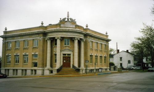 This is the public library in Hannibal; just one of the great old building in town. I think you can see the One Way sign directly in front, I saw it also right after I had made a left hand turn into the lane of an approaching car (they just shook their head at this dumb tourist).
Today took me north on a portion of the Great River Road that parallels the Mississippi River with a stop in Hannibal, MO to Keokuk, IA. The first trial of the day was a spontaneous windshield crack not many miles from Wood River, this is going to be a fight with Scion I'm sure. This happened in a drizzle that became harder rain as I proceeded north. By the time I reach Hannibal, MO (my 2nd crossing of the Mississippi River on the Mark Twain Memorial Bridge) it was raining too hard to walk around and look at the old downtown which is very 1800s. I did go in the library which is a magnificent old building and use their Internet. The scenic views were restricted by the rain much of the time but I could see marvelous farm land in the Mississippi Valley on the IL side.
27 April: Keokuk, IA to Cedar Falls, IA
Roads: US136, IL96, IA2, US63 & City Streets
Distance: 233 miles
Camp: Harold & Sharon's
Route
 On the far left is probably a main street through Nauvoo, IL to the Temple in the distance. The left picture is of the restored home and shop of Browning, the gunsmith famous for the Browning Automatic Rifle or BAR of WWII.
Today's travel takes me through Nauvoo, IL then Fort Madison, Bloomfield, Ottumwa, Oskaloosa and Cedar Falls, IA. I crossed over the Mississippi River again (#3) using the Keokuk-Hamilton bridge into IL and turned north once more to stop in Nauvoo, IL. This was the settlement that Brigham Young abandoned when he led the Mormans to Salt Lake City after Joseph Smith's death. It is a very interesting restored town of the mid 1800s. This was also the home of Browning, the gun maker, and his home/shop has been restored. I then soon crossed the Mississippi once again using the Fort Madison/Niota Toll Bridge (free toll as well as being #4). The Davis County Courthouse in Bloomfield is well worth the time it may take for you to do a Google Image search - it's a real gem. I arrived at Harold and Sharon's around 2:00 in the afternoon and we spent the day reminiscing about our Cycle America trips and the OFC group.
28 April: Cedar Falls, IA
Roads: None
Distance: None
Camp: Harold & Sharon's
Harold and I did a tour of Cedar Falls & Waterloo. He showed me a lot of recreation trails that he uses for his daily bike rides, the Cedar Falls area is very bike friendly. However, because of all the recent rain some of them were under water at the present time and Harold hadn't been riding as much as he wanted to get ready for his annual CA ride. We went past all the old and new John Deer manufacturing plants where Harold had worked his entire career (he has now been retired over 20 years). In the afternoon Harold, Sharon and I did some more touring. Went by the John Deer Engine Plant and Isle of Capri Casino (under construction). Also saw more of the trail system to the south of town that parallels US 63 for some distance, I saw some of the trail as I was driving in yesterday. Harold has a regular 20mile & 30 mile training route that is all on the trails. There are few hills but the trail system keep him out of traffic. We devoted the after dinner hours to watching a video of the 1990 Cycle America across the USA ride and laughing at the antics of the OFC.
29 April: Cedar Falls, IA to Plymouth, IN

Roads: City Streets, US218, US20, US52 & US30
Distance: 366 miles
Camp: Wal*Mart
Route
Today I drove through Dubuque & Sabula, IA then Dixon, Troy Grove & Joliet, IL and finally Valparaiso to Plymouth, IN - three states in one day, I must be in the "East". I crossed the Mississippi again this morning using the Savanna-Sabula Bridge, that is crossing #5. The scenery varied from Mississippi Valley hills along US 52 on the Iowa side (this was another portion of The Great River Road) to almost solid city from Joliet to Valparaiso. Most of the land was rolling hill farm land that was too wet to prepare in IA but it looks like a lot of the IL & IN fields have been planted. It was over 80 degrees today so those that have got seed in the ground will have the advantage of an early crop. Today's roads were also the roughest I have been on so far and I was 5 mph under the speed limit most of the day with the trailer still bouncing badly. There was also a LOT of stop lights on US30 in Joleit, which I expected, but didn't expect so many all the way to Valapraiso. It would have been smarter of me to have dropped even further south of Chicago to avoid the congestion. But part of my route selection process(?) included going through Dixson (President Ronald Regan's boyhood home town) and Troy Grove (boyhood home of Wild Bill Hickock). There was a lot of today's route that followed the historic Lincoln Highway that also passes through Reno, NV and one of the "national" highways that I have read about.
30 April: Plymouth, IN to Northville, MI

Roads: US30, US31, US12, US23, MI14 & City Streets
Distance: 215 miles
Camp: Clyde & Millie's
Route
Today I went through South Bend, IN then Sturgis, Coldwater, Ypsilanti to Northville, MI. Had my first long delay because of construction on US23 but I wasted even more time when I missed my turn off of MI14 because it was access controlled and then wandered around Plymouth, MI for a while until I found the road I wanted to Northville. Most of today was again through small towns and farm land. Part of the route on US12 through Sturgis was also a part of the 1990 Cycle America bike route - however I didn't see where we camped and didn't recognize the town. I unhitched the teardrop for the first time on this trip to park it in visitor parking; Clyde lives in a condominium housing complex (single and multiple dwelling) with no street parking. I then began 2 1/2 days of visiting, shopping and cleaning. Lots of home cooked meals, all prepared by chef Clyde, tonight's featuring leftovers from son & daughters visit of Sat & Sun. Clyde & Millie have only been home 3 days after completing an Around the World cruise on the Cunard Queen Elizabeth II. They had cruised part of the world with Cunard & Holland America, for which they received credit, and this trip from San Francisco to Southhampton, England qualified them for around the world status.
1-2 May: Northville, MI
Roads: None
Distance: None
Camp: Clyde & Millie's
On the 1st Millie went to a hospital for some test while Clyde and I loaded all of his still pictures of their trip from his digital camera to his computer. We did some other computer maintance and I got caught up with my e-mail. The afternoon was then spent watching about 4 hours of his cruise videos. The Clyde (who has Hungarian ancestors) cooked up some stuffed bell peppers, done Hungarian style for dinner. On the 2nd I spent some time preparing for the continuation of my trip - I have been planning(?) this trip on a day by day basis rather than any grand scale design. In doing so I have been contacting friends about a week or two ahead to tell them that I'm coming their way and when is a good time to visit. I then arrange my travel to meet their schedule. Therefore, while I had Clyde's computer available I printed out Google Maps for Ron's place in Rutland, VT as well as Merle's in South Paris, ME. I also printed off some road maps of a suggested route to take tomorrow when leaving Northville - my road atlas is OK but doesn't show the smaller county roads. The afternoon was then devoted to watching the remaining cruise videos. Another great dinner by Clyde; a chicken based Indian dish with garbanzos, fresh salad (which I'm not getting enough of on the road) and corn on the cob.
3 May: Northville, MI to Canton, OH

Roads: N. Territorial Rd, MI52, OH109, OH65, US30 & OH 172
Distance: 294 miles
Camp: Wal*Mart
Route
My travels today were through Ottawa, Upper Sandusky, Bucyrus, Mansfield & Wooster to Canton, OH. I first did some backtracking to the west on N. Territorial Rd. to avoid going directly south into the Toledo area. This took me to MI52 which I then followed south, all of this was quite scenic and a good route. My atlas didn't show it and I probably wouldn't have found it on my own - at last, a "local" with some good directions! The roads south through the western portion were also a good choice, taking me through a lot of small towns and flat farm land (maybe the flattest that I've seen). Then as I turned East after Mansfield the land became more rolling and hilly like what I had been driving through in IA, IL & IN. It took a long time to get approved to stay at the Wal*Mart here in Canton, they apparently have very few people use their parking lot and no one knew quite what to do or who could do it. The section of US30 and MI172 that I was on today were also part of the old Lincoln Highway.
4 May: Canton, OH to Amherst, NY

Roads: OH 172, OH44, US322 & US62
Distance: 301 miles
Camp: Wal*Mart
Route
Today I drove through East Canton, Ravenna & Orwell, OH then Jamestown, Franklin & Warren, PA to Buffalo & Amherst, NY - another three states in one day. I did it all on only 4 highways but put in a lot of time on the road for the relatively short distance. It was probably a bad choice to follow US62 through Buffalo but was reasonably easy to follow the road signs and it appeared the easiest route to Niagara Falls. It did take me about an hour through Buffalo and I decided to stop when I saw a Wal*Mart in Amherst. While in PA I followed the Allegany River from Franklin to Warren along the western side of the Allegeny National Forest. This is a pretty drive with little traffic, lots of small towns and low speed limits. The eastern part of OH and then western PA was more heavily forested than what I have been in with smaller farms. The southwestern part of NY that I went through had an Amish presence with mostly dairy farms. However, I was never out of sight of a house during the day; with some of them looking like trophy houses and a long commute to work. As the price of gas continues up and becomes more scarce, what happens to them?
5 May: Amherst to Herkimer, NY
Roads: US62, NY429, NY31, Streets in Rochester, NY31, NY365, NY49 & NY5
Distance: 255 miles
Camp: Wal*Mart
Route
I tried to follow NY Bike Route 5 today through Niagara Falls, Lockport, Middleport, Rochester, Rome, Utica to Herkimer. I first went to Niagara Falls with the intent of getting a picture. I wasted a lot of time - it is all built up and access controlled if you don't know where to go. (I was subsequently told that it is best to cross into Canada and get pictures from that side of the Falls.) Near Niagara Falls there were a lot of orchards separating corn fields and houses. There are a lot of old Erie Canal towns with the old restored homes lining the route. I got lost in Rochester because of poor signage and would never think of riding NY Bike Route 5 because of that plus it is heavily traveled by cars and trucks. I was delayed by about 1,000 motorcycles in a mass State Police escorted parade that lasted for 15 miles, but the many towns and low speed limits made for a long low mileage day. I don't know exactly where the Tabasco Line is but I crossed it today. The Applebee's that I had dinner at here in Herkimer, NY did not have any Tabasco!
6 May: Herkimer, NY to Rutland, VT

Roads: NY5, NY28, NY29 & US4
Distance: 153 miles
Camp: Ron's
Route
I left NY Bike Route 5 this morning and went through Middleville, Dolgeville, Johnstown, Saratoga Springs & Fort Edward, NY to Rutland, VT. When I stopped for breakfast and asked some "locals" what was a more scenic route they had advised me to take NY28 & NY29. I took their advice and had a good drive through rolling hills, dairy farms, timber and small streams with a lot less traffic. I got into Rutland and stayed lost for a little while because of my entry/results from Map Quest (I've now changed to Google Maps, they are better) but found Ron's (a Peace Corps Volunteer with me). From his computer I sent off an e-mail to Karen & Nora (also Peace Corps Volunteers) asking for a date to visit with them but got no reply today. We walked down into old Rutland downtown to watch the "Loyalty Day" parade and had dinner there before walking back to Ron's apartment. He lives in a subsidized complex tower that is populated with old, infirm or handicapped individuals. He does some work for the Complex on a volunteer basis and works for the Historical Society part time to make enough to live not but certainly not in luxury.
7-9 May: Rutland, VT
Roads: City Streets
Distance: 10 miles unhitched
Camp: Ron's
On the 7th I just loafed around after getting up extra early because I read my watch wrong. I walked to a "dinner" about a mile from Ron's for breakfast but they didn't open until 6:30. I waited around, had breakfast, back to Ron's then we both walked down to Wal*Mart to get motor oil. The Wal*Mart in Rutland is the only one that I have found to be in a downtown area. It was built as part of reclamation of the downtown area where the old train depot had been. There is still an Amtrak stop there but it nothing compared to the old depot complex when trains ruled. Had a good dinner of scrod (a kind of fish and a first time for me) then watched some TV (a unusual activity for me); saw Liala Ali on Dancing With the Stars - she is VERY good! The following day I unhitched the trailer and drove to breakfast and then to a Toyota/Scion dealership. I couldn't get an oil change without an appointment for later in the week - that was strike 1. They then told me that the windshield crack was from a rock -this pissed me off, and I gave them a piece of my mind along with strikes 2 & 3. I went up the street to a local place and they did the oil change in 15 minutes - a Home RUN! On the 9th I wandered around old Rutland for about 3 hours. There are some marvelous buildings from the mid 1800s through early 1900s. Merchant Row has about 1/2 of its store fronts empty and for lease. There is probably an even greater vacancy rate for the upper floor office space. I even saw an empty store in the "Mall" where Wal*Mart is located. The town has gone from a large railroad town with granite quarries and manufacturing to a governmental center and tourist stop.
10 May: Rutland to Cabot, VT
Roads: US4, VT100, VT108, VT15 & Cabot/S. Walden Rd
Distance: 128 miles/ 7 miles unhitched
Camp: Karen & Brad's
Route
Today's route went through Rochester, Duxbury, Stow, Johnson & Cabot, VT. It was a short drive along the eastern side of the Green Mountains National Forest while on VT100. I also passed Ben & Jerry's headquarters but it was a little early in the day to stop for a tour and sample ice cream. Then there was the climb up to Smugglers Notch - a very narrow and winding road near the summit. There were warning signs about no vehicles in excess of 23' and for good reason. I was very fortunate not to meet any traffic in the narrow portion because my total length was probably over the 23' if measured while hitched. It was also so steep that at one point I had to shift down into 1st gear. I stopped for a few minutes in Johnson at Johnson Woolen Mill and looked over their wool products that I have been considering from their internet site. The pants that I was most interested in had been discontinued and I managed to leave with my credit card intact. They have some nice items but all wool is expensive and they are no exception. I arrived at Karen's just after noon and knew that she would still be at work. Brad was working on some additions in Karen's parent's house. The house was built last year and is attached to Karen & Brad's by an enclosed porch, VT law is such that by doing so it is taxed as an addition rather than a new dwelling. Her parents have retired and live in VT for around 8 months and the other 4 at a home in Canada. Her father entertained me until Brad finished his work and I then had him look at my teardrop hatch lock/latch. It had pulled the wood screws loose because of the bouncing and vibration of the trip. The hatch "hold up" rod hook had also pulled out. He determined what he needed to fix it and I unhitched and drove to the Cabot hardware store for the items. It is fixed for now but I'm guessing that continuing vibration will cause me future problems.
May 11: HN Loop
Roads: S. Walden Rd, VT215, US2, NH16, NH112, US302, VT232, US2, VT215, S. Walden Rd
Distance: 210 miles unhitched
Camp: Karen & Brad's
Route
Today I did a loop drive that took me through St. Johnbury, VT and Intervale, Woodstock, NH then Groton back to Cabot, VT. This took me around the White Man Nation Forest and Mt. Washington in NH. I was going to drive to the top but it was raining and the summit was enclosed in clouds, weather on Mt. Washington being what it is I decided it was probably not a good day. I did stop in Intervale and visited with Limmer Boots who confirmed what was causing my blistering/foot problems with my existing boots. My existing boots were Euro made/Euro sizing and because of this they were closer to a size 11 than my 10 1/2 and gave my foot too much room to move around. I had put a lot of training miles in without a problem but extra weight and distance did me in. I got a pair of 10 1/2 Limmer Ultralites from them that I hope solves the problem. If you're in the market for an ALL leather boot I suggest you give Limmer a try. They made custom fit boots as well as the "manufactured" boot that I bought but the waiting list was 42 months long when I was there. The later part of my loop took me through Groton State Forest/New Discovery Sate Park.
12-13 May: Cabot, VT
Roads: None
Distance: None
Camp: Karen & Brad's
On the 12th Karen took me to the Rock of Ages granite quarry this morning for a tour but they don't start tours until Memorial Day. The quarry's primary product is granite tombstones and they had a good sample display outside an information building/gift shop that was open. I could have bought a tombstone even though I couldn't go on a tour. We left there and went to downtown Montpelier and toured the state capital building. An old historic capital with restored Representative & Senate chambers, lots of marble & granite and historic paintings of famous Vermonters. from there we walked through a few block of old downtown, had Ben & Jerry's ice cream and then spent some time at a farmers market. At the market I bought a Pakistani burrito like rollup with mushrooms, garbanzos and "stuff"; also bought a home made loaf of whole wheat bread that was baked in an outdoor oven - good eats. Most of the vendors at the market were "hippie" types and Karen said that the northern part of VT has a very large hippie population. The next day Karen, Brad & I went to Cates Farm to pick up vegetable & flower seedlings. The farm owners (hippie type) had 6 large greenhouses that were planted with tomatoes and one that was for the seedlings. In the spring they have a couple of weekends when they sell the seedlings and people come from all around the Montpelier area to pick them up. That afternoon Karen's dad brought over some "fiddlehead ferns" that he had found while hiking in the woods. He had fried them lightly in butter and wanted me to try some if I had never had them - this is also a spring only treat in the New England states. I added them to my huge dinner salad and with the whole wheat bread it was just perfect!
14 May: Cabot, VT to N. Attleboro, MA

Roads: S. Walden Rd, US2, VT14, US302, US5, NH12 @ Charlestown, MA12, MA2A, @Ayer, MA (W Main St, Sherman Av, Jackson Av), MA2, MA27 & US1
Distance: 267 miles
Camp: Wal*Mart
Route
I drove through 3 states today in less distance than it is across NV, a strange experience for a "westerner". I went through Barre & Groton, VT then Woodville, Charlestown & Keene, NH and Fichburg, Ayer, Natick & Walpole to N. Attleboro, MA. All of US5 and some of NH12 were along the Connecticut River Valley with a lot of small towns, farms and dairies. There were small towns along the entire way to MA27 when it became more like driving in an urban area for the rest of the day. The speed limits were never over 55 and most of the day was at 25 or 35 mph. A lot of wooded areas in MA even along the semi-urban MA27. I made a point of driving through the old Fort Devans where I was stationed with the 104th Fin in 1966-67. I just vaguely recognized the buildings that housed the Army Language/Code School; this is now a redevelopment project for offices and manufactures. I think that my barracks and the Finance office are now in an Army Reserve Training section that was not open to the public. When I got to N. Attleboro I called Nora and she came to pick me up at Wal*Mart and we went back to her apartment to visit and drink a beer while we waited for Ray to get home. We all then went out to a Greek restraint in Providence where I had grape leaves, salad and retsina wine. We had a good visit before they took me back to my trailer for the night.
15 May: N. Attleboro, MA to Montecillo, NY
Roads: US1, RI15, US44, CT74, CT286, county roads Windsorville & E. Windsor, US5, CT140, CT75, CT20, US202, US44, US209, NY52 & NY42
Distance: 239 miles
Camp: Wal*Mart
Route
I did 4 states today but it was a lot like yesterday for driving. I went through Providence, RI then Putnum, West Ashford, Windsorville, E. Windsor, Windsor Locks, Avon & Winsted, CT and Poughkeepsie to Monticello, NY. I was a little lost getting on RI15 to get through Providence and then got a lot lost when I missed my turn from CT286 to CT140 but wandered around on county roads until I got back on track. Even with those missed turns I didn't do much mileage but it was a long day. Almost all of CT & NY were wooded with all of RI urban. Once I was into NY I saw a lot more farms and orchards - apples on the west side of the Hudson. The area near the Catskill was heavily Jewish and appears to be a tourist economy. I crossed the Hudson River at Poughkeepsie and there were huge signs proclaiming it to be the home of President Franklin Roosevelt; he was from Hyde Park, NY a few miles to the north but they need to brag about something. Then passed through Minnewaska St. Park on the western side of the Hudson Valley; it seems to be either an up thrust limestone plateau or the land around it was eroded away. There was a great view from the top on the eastern side of the Hudson Valley. Today's Wal*Mart was the first one that could not give me permission to park in their lot overnight - there is a county ordinance prohibiting such "camping". However, the manager told me "if you don't unhitch there is no way that I can tell that you're NOT just another customer". I stayed the night!
16 May: Montecillo, NY to Gettysberg, PA

Roads: NY42, NY97, US209/US Bus209/I-80, PA93, US11, PA34 & US30
Distance: 302 miles
Camp: Wal*Mart
Route
Along my travel route today were Port Jervis, NY then Stroudburg, Hazleton, Bloomburg, Newport to Gettysburg, PA. It was a longer mileage day as well as time. Most of the day I had speed limits of 45 mph and when it was greater than that I sill drove 45 because it was raining so hard. I got to see some of the scenery in the upper Delaware River Valley while on NY 97. However, soon after crossing into PA I was in light to heavy rain the remainder of the day. I had very restricted visibility while driving along the Susquehanna River on US 11. I did notice a lot of apple orchards along PA34 to the north of Gettsburg.
17 May: Gettysberg, PA to Keyser, WV

Roads: US30, City Streets/Gettysburg Battlefield, US30, US220/I-68/US220
Distance: 138 miles/ 19 unhitched miles
Camp: Wal*Mart
Route
I did another 3 state day - passing through Chambersburg & Bedford, PA then Cumberland, MD to Keyser, WV. I got a break in the weather and had a very sunny day to do the Auto Tour of the Battlefield. The Park Information Desk gave me a map to follow for the Tour - managed to only screw up twice. The roadside signs are quite good but most of the Park roads are one way and the map does not show ALL the directions of travel. The best advice that I got from the Desk was to unhitch my trailer. As I traveled west on US30 I noticed that I was back on part of the Lincoln Highway once again with three serious climbs and downgrades - these had to be real trials in the 1920s. These were long steep grades that had me in 3rd gear longer than any other climbs on the trip but maintained 40 mph and pulled them fine without exceeding 4,000 RPM. When I passed through Chambersburg I was about as close to James Buchanan's hometown of Mercersburg, PA as I had been to FDR's but they didn't brag about it. I crossed MD through Cumberland then over the Potomac River into WV. The Wal*Mart in Keyser is quite far south of the town, probably because US220 is in a very narrow valley and it was difficult to find a large piece of flat land.
18 May: Keyser, WV to Staunton, VA

Roads: US220/US50/US220, US250/ I-81
Distance: 145 miles
Camp: Wal*Mart
Route
Today I drove through Moorefiled, Franklin & Monterey, WV to Staunton, VA. It began to rain at 9:00 pm and has continued all morning while I was driving in WV. I didn't get out of it until I crossed over then Shenandoah Mountains through George Washington National Forest into VA. The climbs over the Shenandoah Mats were even steeper than what I had in PA with hairpin turns at 20 mph downhill and 2nd gear on the uphill. I had originally planned on driving Skyline Drive from north to south but with the heavy rain this morning I thought I'd take my chances on a south to north direction tomorrow. The forecast is for sun! I was very confused by the US250 signage in Staunton so did a couple of miles on the Interstate to reach the northern side of town and the Wal*Mart here.
19 May: Staunton, VA to Gafton, WV
Roads: US250, Skyline Drive, US340, VA55, US11, US50/US220/US50 & US119
Distance: 275 miles
Camp: Wal*Mart
Route
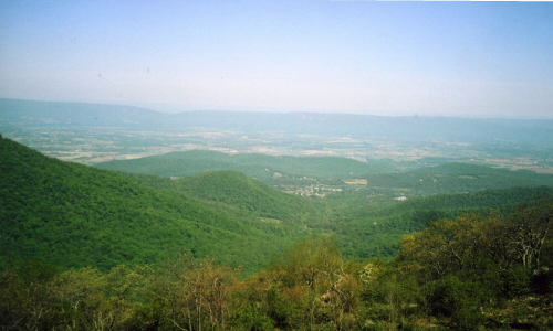 A picture from Skyline Drive of the Shenandoah Valley
Skyline Drive has no towns and only 2 cross highways between the southern entrance near Waynsboro and the northern exit near Front Royal. From there I drove through Winchester, VA and then through very small town in WV to Gafton, WV. I'm taking credit for 3 states in one day again although my crossing of MD was only 7 miles on US50 from Gorman, MD to the western border. I was back on US50 once again for about 115 miles and it took 4 hours. There were multi climbs/descents of 7, 8 & 9% grades while crossing WV and I'm not across it yet. Today convinced me, for all time, that the xB can tow this teardrop trailer anywhere there is a paved road! I did have sunshine for Skyline Drive but there was evaporation in the air that reduced the visibility to the east and only 2 or 3 ridges to the west. The Shenandoah Valley was clearly visible and I stopped at almost all the overlooks on the left side of the Drive. My decision of yesterday was a good one plus the Park is a National Park and my Golden Age Passport saved me $15 - one of the greatest purchases that I have made in my life and one of the very few advantages of getting old. I was lucky, it started raining again at sundown. Historical Note: In Grafton, WV in 1908, Anna Reeves Jarvis's (first woman to hold an official celebration of mothers) church acquiesced to her daughter's request to hold a special Sunday service in honor of mothers - a tradition that spread the very next year to churches in 46 states.
20 May: Gafton, WV to Maysville, KY

Roads: US119, US50 & US62/KY9
Distance: 368 miles
Camp: Wal*Mart
Route
I was mostly on US50 through Clarksburg & Parkersburg, WV then Athens, Chillicothe & Hillsboro, OH to Maysville, KY - another 3 state day. I was not too far from President Grant' boyhood home just northwest of Maysville, but again they didn't brag about it. It was a cloudy morning with fog in the "hollers" but no rain. I had just a few sprinkles as I turned south on US62. It was a lot warmer in southern OH and it felt hot and humid when I crossed over the Ohio River on the Simon Kenton Memorial Bridge into Maysville this afternoon. The clouds are building up for what I would expect to be a thunder storm but I don't know the area or the forecast. I saw that some of the OH fields had 6" corn but others are just now being tilled, I'm guessing they have been to wet to work. The same situation with the hay; saw a lot of fields that were cut but only a few had been baled. Most of the cut hay has been rained on and is drying out so they can bale it.
21 May: Maysville, KY to Vincennes, IN
Roads: KY9, KY10, KY22/US25/KY22, KY389, KY193, US421 & US 50
Distance: 298 miles
Camp: Wal*Mart
Route
A lot of small town in KY - Brooksville, Williamstown, Dry Ridge & Port Royal, KY then Madison, Versailles, Seymour to Vincennes, IN - giving me another 3 state day. All of the roads that I took across KY to Port Royal (home of Wendell Berry, a favorite author and my reason for going through there) were very twisty. I followed ridge lines most of the way with no trees so I had some of my best views while in the "east". (NOTE: My friend in VT & RI will contest that statement and say I was in the west.) I also saw a horse drawn trailer with "flats" of seedlings that I guessed was tobacco and one field that had just been planted. It was mostly grass land however and I saw a lot of baled hay. The corn in KY and IN was 8-9" or once again the fields had not been worked yet. I crossed back over the Ohio River on the Milton-Madison Bridge to Madison, IN. Just north of town along US421 I saw a lot of signs for the Army Jefferson Proving Ground and then Big Oaks Nat Wildlife Refuge. The gunnery range was closed in 1989 but is apparently still being cleaned up but about 50,000 acres of the grounds north of the historic firing line became Big Oaks. Once I had crossed the Ohio River into IN it became very flat vs. the hill country that I had driven in KY. Then as I neared Vincennes (boyhood home of Red Skelton) it became more rolling once again.
22 May: Vincennes, IN to Fredericktown, MO
Roads: US 50, IL4, MO51 & MO72
Distance: 236 miles
Camp: Wal*Mart
Route
I was following US50 again through Salem, Lebanon & Chester, IL to Perryville & Fredericktown, MO - Vincennes is right on the IL border but what the HAY another 3 state day. I saw lots of corn today. The southeastern portion of IL was table flat with just a few very small hills once I turned south.
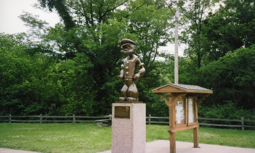 A 6 ft. bronze Popeye statue located in the Segar Memorial Park in Chester, IL the home of his creator.
The Popeye statue and Segar Memorial Park were near the Chester Bridge - my 6th crossing of the Mississippi. The statue was erected to honor Elzie C. Segar, the creator of Popeye, who was born in Chester and many of the Popeye characters were modeled after real residents of Chester. I was thinking of camping a few days in the Mark Twain National Forest in MO but they have no showers. It was quite hot and humid this afternoon and evening, must be nearing summer.
23 May: Fredericktown, MO to St. Joe State Park, MO
Roads: MO72, US67, County W & B
Distance: 30 miles/12 miles unhitched
Camp: St. Joe State Park
Route
I drove into Farmington, Mo for breakfast and picked up a magazine to keep me entertained for a couple of days. Then found St. Joe's although the road designations differed from what was on my map. I paid my camping fee only for today but will probably stay through the 28th, Memorial Day Weekend, and stay off the roads. I was really great to have a shower for the first time in 9 days - the baby wipe bath works but it's just not the same. When I went to Park Hill, MO (nearest library) for Internet access, I sent an e-mail to my Reno UPS Store telling them to forward my mail to Minden, NE. Then had dinner, read and bed.
24-29 May: St. Joe State Park, MO
Roads: Local
Distance: 174 miles unhitched
Camp: St. Joe State Park
All of my days in the Park were generally the same; drive into Leadington for breakfast, come back and read, maybe nap, shower, and drive to dinner, read until dark then bed. I also sat around and thought, with one of my thoughts being about my paternal grandfather who had divorced my grandmother long before I knew her. I never did know him but the family story was that he saw me when my parents took me to MO as an infant. It was also a family story that he worked as a lead miner. It just so happens that St. Joe is an ATV park that uses the old mine tailings of the Missouri Mines State Historical Site for their trail riding. It just may be that I'm camped just miles from where my grandfather once worked these lead mines - just a thought. On the 24th I went back to the Park Hill library to check e-mails and also bought 3 books from them - total cost $0.30, my best buy in a long time! Got my laundry done had dinner and made it back to camp in heavy rain then on and off rain through the night. I went back to the Park Hill 3 times to check e-mail and bank balances then on the 29th I took one of the 3 books that I bought from them and gave it back to them. However, I bought a replacement - I just couldn't pass up the $0.10 bargain!
30 May: St. Joe State Park, MO to Mark Twain State Park, MO
Roads: County B, MO32, US67, MO47/MO21/MO47, County D, M, O, T & BB, MO19/US54/MO19, MO154 & MO107
Distance: 179 miles/29 miles unhitched
Camp: Mark Twain State Park
Route
Today I went through Leadington, Bonne Terre, Union, Washington, Warrenten, Hawk Point, Scott's Corner, Perry Junction & Mark Twain State Park. It started to rain again just as I was hitching up and continued heavily for the first hour; didn't see anything but the trees on both sides of the road. It slowed to off/on by the time I crossed the Missouri River for the 7th time on Highway 47 Bridge at Washington. The view opened up on the northern side of the river with lower hills, less timber and more corn and wheat. I checked into my camp spot which is operated by MO Parks but Mark Twain is a part of the US Army Corps of Engineers Lakeside Recreation system and my Golden Age card is good for them also - 1/2 price -YES! I also determined where I can get breakfast and dinner; Perry, Paris & Perry Junction. Had a few sprinkles after dinner and then hard rain around 1;00 am that kept me up for a little while.
31 May - 9 Jun: Mark Twain State Park, MO
Roads: Local plus Paris, MO to Mexico, MO Loop
Distance: 453 miles unhitched
Camp: Mark Twain State Park
My camp life here is much the same as at St. Joe; - eat, read and sleep. On the 31st I went to Perry Junction for dinner and to get gas. When I arrived there was one of the Budweiser Clydesdales in the parking lot. It has been a long time since I have seen one of them and I had forgotten how huge they are when seen "up close and personal". It also appears that each horse has its own 40' trailer to travel in, a driver and a handler for each one. That is an EXPENSIVE team of horses to maintain! On the 1st I hiked "Post Oak" & "White Oak" trails in the Park that where listed as 3 miles total.
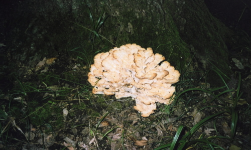
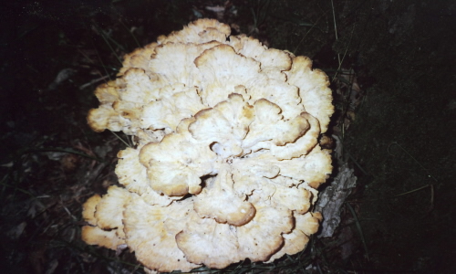
I saw a very unique mushroom on the White Oak - maybe 16" across and had petals like a flower. I'm going to go back tomorrow with my camera and try for some pictures. It wasn't very hot and there was a slight breeze but the humidity is high and I was sweating rivers. Early this morning of the 2nd I was awakened by a thunder storm but not much came of it. I did the same hike as yesterday, but counterclockwise this time, and got some pictures of "my" mushroom. It was even more humid today and I picked up a fine crop of fleas from the grass along the trail. The fleas, mosquitoes and biting flys are chewing me up. On the 4th I did my Mexico, Mo Loop. I did it as much for bragging rights as for anything else - I can now say that I have driven from Paris to Mexico! The Roads: MO107, MO154, MO15, US Bus54, MO15, County Z, ZZ, D & E & MO107.
While in Mexico I stopped at Wal*Mart and got some more TrackPhone minutes, some Deet and had a good breakfast. The 5th was just another day until around 7:30 pm when a motorcyclist came in and camped next door. We had a very long conversation about our travels - he is on his 4th cross country trip but does LONG miles every day vs my short mileage. He is from AL and this is his first day on the road. On the 6th I finished my second of the 3 book that I got at Park Hill. I need some replacements or make the remaining one last. My selection process was based on the volume of pages for each book, I wasn't looking at subject matter simply volume but I'm running out of reading material. The night of the 7th I got very hard rain again and the trailer leaked a lot. This was the hardest rain that I have had but was very lucky that it didn't last very long. My last two days at Mark Twain were filled with the same eat, read and sleep. With one exception, I did drive over to Florida - that's Florida, MO and Mark Twain's Birthplace State Historical Site. It is now a "town" of maybe a dozen houses and the cabin that Mark Twain was born in.
10 Jun: Mark Twain State Park, MO to Nortonville, KS
Roads: MO107, County U, US24, MO10, MO13, MO116, US59 & US159
Distance: 228 miles
Camp: Al & Kay's
Route
My route today was through Moberly, Richmond, Plattsburg, MO to Atchison & Nortonville, KS. I was in very heavy rain for about 30 miles after I left Mark Twain this morning with it decreasing as I approached KS. I stopped briefly in Atchison (birth place of Amelia Earhart) after crossing the Missouri River for the 8th time on Amelia Earhart Memorial Bridge. I arrived at Al & Kay's (cross country bicycling friends) to find that the inside of the trailer was quite wet which was no big surprise. We devoted the afternoon to catching up on our lives, checking e-mail and sending one to Borge & Elaine (also cycling friends) about a July visit. I had confirmation that my mail from Reno UPS Store should be at the Pioneer Village in Minden, NE. Historical Note: Lewis and Clark camped on July 4, 1804 at what they called Fourth of July 1804 Creek (since 1854 when Atchinson was settled it has been known as White Clay Creek).
11-12 Jun: Nortonville, KS
Roads: None
Distance: None
Camp: Al & Kay's
On the 11th I devoted about 2 1/2 hours to washing the xB and trailer, they both have taken a beating on this trip. It was a cloudy morning and the humidity felt like it was at 110%, I was dripping wet from the car washing effort. I also opened up the trailer hoping that it would dry out somewhat with a breeze blowing. I also discovered that all 3 mattress pad were wet whereas I had previously thought only the rear 2 got soaked. The one toward the front of the trail has been wet before and has added some water damage to the front inside wall. The big event of the 12th was to provide a trailer tour for 2 of Al & Kay's grandchildren - they seemed impressed! The other biggie was my selecting 3 paperback books from Kay's "giveaway stack" of about 20. I once again went for volume and didn't concern myself much with the book topic.
13 Jun: Nortonville, KS to Minden, NE

Roads: US159, KS116, KS16, US77, US24, KS181/US281, US36, KS8 & NE10
Distance: 288 miles
Camp: Pioneer Village
Route
Some of the towns that I passed through today were Holton, Clay Center, Beloit, Cawker City, KS then Franklin & Minden, NE.It rained all day, very heavy in the morning and then steady for the remainder. I didn't get too much because of it. However, I did see the World's Largest Ball of Sisal Twine in Cawker City, KS. It is right on the "Main Street" of town, US24. It was raining too hard to stop and go up to it but I looked it up later; this thing is BIG - 40' in circumference and weighs 17,980 pounds.
 A picture of the monument at the Geographical Center of the United States.
I also went out of my way and then backtracked to see the Geographical Center of the United States (a small monument). Two years ago when I went to Minden I was going to stop and see it but missed the turn off so this time I didn't want to do it again. I went to the Minden town square for dinner and also stopped at a barbershop and inquired about what hours she was open - she said "sometime between 8:30 and 9:00".
14-19 Jun: Minden, NE
Roads: None
Distance: 49 miles unhitched
Camp: Pioneer Village
It was still raining on the 14th and I said that if it was doing so tomorrow I was going to start driving north until it stopped! Went downtown again for breakfast and then got to the barbershop at 8:20 where I waited under the roof eaves until 9:30. I went next door for a few minutes to inquire about when the library was open and when I came out I saw that she had opened. when I got to the library I was still early so I found a dry place to sit and wait - they were to open at 11:00 and opened their doors at 11:10. It seems that opening times in small town NE are a lot like Bulgaria; they open when they open. I did check e-mail and inquired about exchanging books and the Liberian said she would. It did not rain on the 15th so I stayed. I opened up the trailer and took the mattress pads out once again to dry out, there had been a lot of water thrown under the doors on the 13th as I was meeting trucks that day. The hatch leak was not too bad but it still leaks. Went back and did a book exchange so I now have 3 "new" unread books. For the remainder of my days I got back into my normal camp routine of eat, read, and sleep with some walking around and looking at other Teardrop Trailers. The reason for being here was the 2007 International Teardrop Gathering so that was required. I also spent a quite a bit of time talking to a fellow that had a Lassenview teardrop that he was towing with his MINI. Two years ago he had spent a lot of time talking to me about my MINI and said that he was going to buy one. On the 16th I drove up NE10 & US30 to Kearny, NE for a Mexican food dinner that wasn't very good but I was going through withdrawals.
20 Jun: Minden, NE to Pierre, SD

Roads: US6, US81, NE121, Gavins Point Dam, SD52/SD50/52, SD37, SD50/46, SD50/US18/US281, SD50, SD50/44, AV350, BIA2, SD50, BIA4, SD47, BIA5, lost on back roads, BIA10, SD1806 & US Truck83
Distance: 516 miles
Camp: Wal*Mart
Route
Today's route took me through Hastings, Columbus & Norfolk, NE then Yankton, Yankton Indian Reservation, Crow Creek Indian reservation, Lower Brule Indian Reservation to Pierre, SD. It was one of my longer days, longest in mileage, in time and almost daylight - tomorrow is the longest day. When I went through Columbus & Norfork, NE it was the first time I have been back since the summer of 1961 when I worked there for Procter & Gamble handing out fee samples door-to-door. I stopped at the Lewis & Clark Recreation Area near Yankton and picked up maps for SD, ND, Lewis & Clark as well as US Army Corps Recreation areas. Crossed the Missouri River on the Gavins Point Dam for time #9. I then tried to follow the road map symbols for the Lewis & Clark Trail but maps and roadside signs didn't always agree. I also missed my turn onto BIA10 and went 10-15 miles out of my way to who knows where - I think I was in the West Big Bend Recreation Area of the Lower Brule Indian Reservation. This was after wandering through the Crow Creek Reservation and doing crossing #10 on Big Bend Dam at Fort Thompson, SD. The 100 mile stretch of highway from Chamberlain to Pierre is the only designated Native American Scenic Byway in the US. Once I got back on track BIA10/SD1086 it lived up to its name with wonderful views of the Missouri River; the down side was about 1 mile of VERY rough road under construction and 10 miles of gravel road but the scenery was worth it. It was not a 3 state day but with my 10th crossing on Fort Pierre Bridge - it was a 3 crossing day.
21 Jun: Pierre, SD to Bismark, ND

Roads: US Truck83, SD34/US14, SD63, US212, BIA7, US212, US83, US12, SD1806, BIA3, ND24/ND1806, BusND94 & Bismark Expressway
Distance: 326 miles
Camp: Wal*Mart
Route
Today I drove through the Cheyenne Indian Reservation, Forest City & Mobridge, SD then the Standing Rock Indian Reservation to Madan/Bismark, ND. In trying to follow the designated Lewis & Clark Trail on my SD maps I have found that any/all roads near the Missouri River have L & C Trail signs. There was heavy rain to the north and east of Pierre this morning with tornado sightings. I left Pierr to the west (back across Fort Pierre Bridge for #11) before I turned north and then back to the east. I was going to take BIA7 through the Standing Rock Indian Reservation but it was very muddy from this morning's storm so I turned around after two miles. I then crossed the Missouri once again (#12) on the Forest City Bridge, turned north, back across the Missouri (#13) on Bridge Mobridge to the Standing Rock Reservation once more. More than 1/2 of my SD trip has been on Indian Reservations with great grasslands, lots of hay & horses with very few houses. The Standing Rock is a Sioux Reservation but Sacajawea (a Lemhi Shoshone) is buried near Kenel, SD (there are conflicting stories about her life and where she is buried). Sitting Bull, who was Sioux, is buried not far north of there near Ft. Yates, ND; the Standing Rock Reservation is in both North & South Dakota. I crossed the Missouri for the 4th time (#14 so far) today on the Liberty Memorial Bridge (Old)Business-94 from Madan to Bismark. I found the twin cities to be much larger than I had thought and there was traffic to match their size. The Wal*Mart that was listed in my Locator has been closed and a new Superstore opened on the southeast side of town. I was just lucky to stop and ask directions before finding the closed one! Just as I was getting ready for bed I had visitors stop and talk - it was a fellow teardroper that had been at Minden. We had not met while at Minden but they saw me in the parking lot when they came to pick up their finished picture prints that they had taken while there.
22 Jun: Bismark, ND to Fort Peck, MT

Roads: Bismark Expressway, 43rd AV, US83, ND1804, US83, ND200A, ND200, ND22, ND73, ND23, US85, US2 & MT117
Distance: 367 miles
Camp: Fort Peck Recreation Area
Route
The town along today's route were Washburn, Hazen, Killdeer, Watford City & Wiliston, ND then Fort Peck Indian Reservation & Fort Peck, MT. I passed a second Wat*Mart this morning on my way out of Bismark at 43rd AV & US83, perhaps a better choice. I crossed the Missouri #15 on the Washburn Bridge and started switching back and forth between Central and Mountain time for most of the day until I entered MT (very confusing). The more scenic river crossing was in the North Dakota Grand Canyon that has been cut by the Little Missouri River on the Fort Berthold Indian Reservation. The second Missouri River crossing of the day (#16) was Lewis & Clark Bridge at Williston. I have seen a LOT of wheat during the last two days but it has been getting greener and greener as I've moved north, they are probably harvesting in MO now but it will be least a month more here. I have also been seeing wild turkeys for the last 3 days, but today there were also four chicks. It has been HOT here in the central part of the country since I left Minden, I'm trying to hurry along and get to the Rockies for some relief. I called Jody (a friend that I worked with at First Trust Bank in CA) and told her that I would be arriving on Jun 29th and leaving on July 5th if that was OK. I'll stop somewhere along the way for about 4 days where it's cool. Historical Note: Washburn is where the Lewis & Clark Expedition arrived on October 25, 1804, built Ft. Mandan and wintered over. It is also where they met Sacajawea and where her baby Jean Baptiste Charbonneau/"Pomp" was born in Feb 1805.
23 Jun: Fort Peck to Great Falls, MT
Roads: MT24, US2, US87 & Northwest Bypass
Distance: 284 miles
Camp: Wal*Mart
Route
Today I went through Glasgow, Fort Belknap Indian Reservation, Havre, and Boy's Indian Reservation to Great Falls, MT. Today was not as long as my previous 3 but I was tired by the time it was done, maybe the cumulative days is catching up with me. There was wheat and more wheat today. The first mountains that I have seen in a long time were the Killdeers in ND yesterday, then the Bear Paws today were visible from Ft. Belknap on US 2 all the way to Big Sandy on US87. I see some more to the south of Great Falls and should be in them tomorrow. The weather forecast is for cooler temperatures today and tomorrow with it being much cooler starting on Monday. I'm thinking that if the forecast holds true I'll stay at an Army Engineers Dam site in ID or WA for the 4 days. The Wal*Mart here in Great Falls is right across the road from a oil refinery and tank farm but is not a penny cheaper than it was in Chinook some 130 miles away. While I was filling up there I had a teardrop builder "wanabe" look my trailer over and question me for a long time - ya have to plan on traveling on "teardrop time" if ya have one.
24 Jun: Great Falls to Missoula, MT
Roads: Northwest Bypass, US87, US89, US12, US287, MT2, MT69, MT55, MT41, I-15, BIA278, MT43 & US93
Distance: 429 miles
Camp: Wal*Mart
Route
I was driving through a lot of small towns today including White Sulphur, Townsend (a campsite for the 1990 Cycle America Tour), La Hood, Dillon, Wisdom, Hamilton to Missoula, MT. My first Missouri crossing (#17) was in Great Falls on 15th St Bridge and my last (#18) was Toston Bridge just south of Townsend. The headwaters are only a few miles further south at Three Forks where the Gallatin, Madison & Jefferson Rivers join to become the Missouri. I followed along the Jefferson until Dillon, but it wasn't all river valleys it was also 5 passes with a valley between each one. It was wonderful to be back in the mountains! Back in the pines, sage brush, flowing streams and grass everywhere. No where more so than the Big Hole of MT. This huge grass filled valley had to have been paradise to deer, elk & buffalo at the time of Lewis & Clark. Today it is a heaven to black angus cattle on ranch after ranch. A good part of my travels today were not only the L & C Trail but also along the Nez Perce Trail. I crossed the Continental Divide at Chief Joseph and Lost Trail Passes - I didn't see any road signs but my map and the direction of the Bitterroot River flow tells me that I did. It is about 170 miles from Great Falls to Missoula via MT200, I managed to turn that into 429 miles of pure joy. I went to a Chinese restraint last night and my fortune cookie read "You will have a happy adventure soon". I got it today! Missoula was the second , and last, Wal*Mart that said I could not park over night because of a city ordinance against such camping; however, the manager said that the ordinance had never been enforced at Wal*Mart. I thanked her very much and told her that we had never had this conversation and if I were rousted I would simply say I was so worn out from driving that just had to stop. I stayed the night!
25 Jun: Missoula, MT to Pasco, WA

Roads: US93, US12, WA124 & City Streets
Distance: 348 miles/16 miles unhitched
Camp: Hood Park
Route
Today I did my last 3 state day through Lolo, MT then the Nez Perce Indian Reservation & Lewiston, ID to Dayton & Pasco, WA. I started raining at 5:00 am; was very hard at times and continued until I reached the summit of Lolo Pass. From the summit it was 170 miles of almost all downhill to Lewiston and a very good thing or I would have run out of gas. There was a sign near the summit that said next gas was 65 miles and I knew that I could make that but at the 65 mile mark I found no gas. It was 85 miles to Kooskia, ID with the low fuel light on for over 20 of them before I could fill up. Because of the downhill yesterday and this morning I got 36 mpg on this tank - with the trailer! When I got to Pasco I had a hard time finding the Army Engineer Recreation campground that their map identified as Sacajawea. There was a park by that name on the north side of the Snake River and downstream of the bridge but it was day use only. Where I camped was called Hood Park which I had passed coming into Pasco; it is on the south side of the Snake and upstream of the bridge. It is run by the state of WA but like Mark Twain I got my 1/2 off rate. It was all timber along the Clearwater river in ID then saw a lot of wheat from Alpowa Summit to Prescott, WA changing to fruit orchards near Pasco. The labor force for all those orchards live in "old" Pasco which is a "Little Mexico" downtown. I have a great shady camp spot, good showers and not far from town - probably stay here until Sat. and rest.
26-29 Jun: Pasco, WA
Roads: Local
Distance: 104 miles unhitched
Camp: Hood Park
I was back into my camp life routine - eat, read and sleep. I went into Pasco every day for breakfast and dinner and because of "Little Mexico" I was able to find a different Mexican Restraint for every dinner. Had all my breakfasts at the same place that was closer to camp and was also close to laundry that I took advantage of one day. The Pasco library did a book swap for the three that I had acquired in Minden (so for $0.40 I have managed to get 10 books while on the road) as well as provided an Internet connection. I sent an e-mail to Lassenview to set up an appointment to discuss a new teardrop, hope to stop and see him on my way to Reno. I tried to see the Sacajawea Museum two different times; the first time I was too early (opens @10:00 am) then on the 29th there was some kind of Indian Ceremony going on and it was closed. I spent two evenings visiting with two couples that were camped across the road from me. They were from the Spokane area and came here for a week about this time every year.
30 Jun: Pasco to Battle Ground, WA
Roads: US12, US730, US395, WA14, WA500, WA503 & City Streets
Distance: 240 miles/24 miles unhitched
Camp: Jody's
Route
Today I followed the Columbia River, after crossing over McNary Dam, on the WA side through a lot of small towns until I turned north at Camas then to Battle Ground, WA. I have reasonably trouble free but today was one of problems; first I got lost between WA500 & WA 503, then put a large bolt through the tread and sidewall of left rear tire on the xB. I got it changed and found Jody's after some misdirection driving. She lives on 240th AV and the Avenues run E-W, the Streets/Roads run N-S, but for reasons unknown 237th Av becomes 240th AV which runs N-S. The problems continued when I unhitched and couldn't get the "D" link in the safety chain to come apart (had to borrow pliers to get it loose - why(?), and lastly I lost the cotter pin to the hitch receiver bolt. However, my luck did change when I went into downtown Battle Ground and found a tire the correct size at Les Schwab. Jody and I then spent the remainder of the day visiting.
1-4 Jul: Battle Ground, WA
Roads: None
Distance: None
Camp: Jody's
My days with Jody were much like when I'm camped with the exception that I had someone to visit with. I devoted one morning to washing the car and trailer to get the SD mud off of them that I have been carrying across country. Then on another day we went shopping. But most of my time was spent visiting, eating, reading & sleeping; with a little TV added in (I have been without a TV for so long now that I find it difficult to find anything worth watching - it is an acquired habit). Jody lives in a "mother-in-law" house with her daughter and provides baby sitting for her grandson and granddaughter. Her health has not been the greatest over the last few years and while e I was there she had a bad cough that she couldn't shake. Her son-in-law provided fireworks for the kids on the 4th but with sundown being so late I was in bed by the time he started the show. Historical Note: Battle Ground is ironically named for a battle that never happened. In 1855 local settlers feared that the Klickitat Tribe would join an uprising by the Yakima Indians so they were ordered to Vancover. When some did not comply they were located where Battle Ground now stands, but a battle was never fought and the Klickitat returned peacefully.
5 Jul: Battle Ground, WA to Klamath Falls, OR

Roads: City Streets, WA503, I-205, US26, US97, OR138, Crater Lake, OR62, US97/Bus97 & Washburn AV
Distance: 337 miles
Camp: Wal*Mart
Route

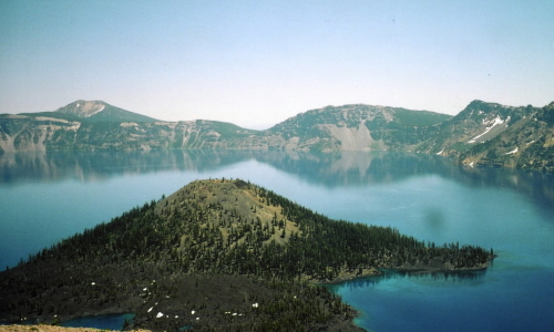

Today I went through Vancouver, WA then Portland, Bend, Crater Lake to Klamath Falls. it was an easy transit through Vancover, over the Columbia River and Portland on the I-205 & US26 - I heard on the radio that I-5 was a mess because of an accident. From US26 I had a very good view of Mt. Hood and the Sisters, near Bend, were still spectacular with their snow covering. There were large patches of snow at Crater Lake National Park, (once again my Golden Age card paid dividends) also but not inside the crater. The climb up to the crater rim was steep enough to keep in 3rd gear most of the way. Once I was there I stopped at 2-3 view points and it is a spectacular sight, one of the must see places in the USA if not the world. Other than at Crater Lake it was hot almost all day so I have decided to try camping near Mt. Lassen tomorrow for some cooler weather. Redding, CA will be HOT, HOT for sure, the high in Klamath Falls reached a record 98 degrees today.
6 Jul: Klamath Falls, OR to Old Station, CA

Roads: Washburn AV, OR140, OR39, CA139, CA299, CA89 & CA44
Distance: 209 miles
Camp: Hat Creek Camp Ground
Route
The route today took me through small towns and National Forests with an extra 40 miles added to my efforts when I turned the wrong direction on US44. after I corrected my mistake I returned to Old Station and picked up something for dinner and then camped at Hat Creek Camp ground a few wiles west toward Redding, CA. The camp ground is a CA park but they also honored my Golden Age card (I've saved $187 this trip with the card) - the card and my book buys haven't offset my fuel bill but have helped! I'll go to see Lassenview in the morning and then home.
7 Jul: Old Station , CA to Sparks, NV

Roads: CA44, CA36, US395 & City Streets
Distance: 199 miles
Camp: Home
Route
I stopped in Shingle Town, CA for breakfast and found where Mike of Lassenview Custom Teardrops lives. We talked for an hour about what I wanted in a new trailer and could he build it to weight less than 400#. He thinks that he can get it down to that weight or very close and I left him with the understanding that I would bring him my wheels off of my current trailer sometime next year. I then backtracked on CA44, past my campsite, to Susanville, CA. There was a large forest fire to the southwest of Susanville that was pouring a lot of smoke across US395 but not enough to cause traffic delays. I arrived in Sparks by mid-afternoon and 100 degree temperatures. Checked into a motel with air-conditioning for the next month, will empty out the car and trailer in the morning when it is cooler. Then I start preparing Pandora for sale, she has been good to me but it's time for a new home for her and a new trailer for me.