My 2008 Quest
September 1 to October 31, 2008
The Summary
Miles with Dapple (My Scion xB): 11,548
Miles with Casa del Panza (My Teardrop) in tow: 11,055
Interstate Highway Miles: None
Fuel Economy: 33.95 mpg
Duration of the trip: 61 days
Nights in Pandora: 47
States Visited: 39
Teardrops in tow sightings: 2
Total Trip

1 Sep: Reno to Rachel, NV

Roads: City streets, US395, US50, ALT US95, US95, US6, & NV375
Distance: 355 miles
Camp: Little A'le'inn Dry Camp
Route
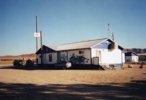 You can not see the sign very well on the top of the pole by the building but it says 'Alien Parking Only'.
I drove through Carson City, Yerington, Hawthorne, Tonopah to Rachel at about the mid point of the Extraterrestrial Highway. In doing so I was on two of the longest highways in the US, US 50 & US6, however neither of them reach from coast to coast. The first day of travel on a trip is always a bit of trouble for me - I am excited and can't sleep very well the night before. It was much colder this morning when I started loading up the car and trailer at 5:00 am. It has been in the low 60s, this morning it was in the mid 40s with Lake Tahoe at 30 degrees. I have been back and forth across NV enough now that it has become somewhat boring but I'm always impressed with the range and basin, range and basin that never seem to stop. I stopped for breakfast in Yearington, NV and gas in Tonopah, NV where it was windy and still cold. I got permission to set up a dry camp next to the A'le'inn bar/restaurant/motel for the night - the only commercial establishment in the town of Rachel, NV (population about 100). If Rachel, NV is not the most isolated town in the "lower 48" it has to be in the top 10 - over 100 miles to Tonapah and about 150 miles to Las Vegas, NV.
2 Sep: Rachel, NV to N. Rim Grand Canyon, AZ

Roads: NV375, US93, NV319, UT56, UT18/Bluff St/Riverside Dr, Telegraph St, UT9, UT59, AZ389, ALT US89 & AZ67
Distance: 332 miles
Camp: North Rim Grand Canyon Campground
Route
Today I went through Caliente & Panaca, NV then St. George & Hurricane, UT to Fredonia, Jacob Lake & North Rim Grand Canyon,AZ. I stopped at Caliente, NV for breakfast and the use of a bathroom - for me that is the biggest disadvantage to "cold camping", the lack of bathroom facilities in the morning. I stopped again in St. George at a Starbucks to use their WIFI. I made arrangements prior to starting this trip to use WIFI at Starbucks locations by getting a Starbucks Card, registering it with Starbucks and AT & T; this would then give me 2 hrs of usage with AT & T each day at a Starbucks. However, the plan was not available in St. George, UT; they had T-Mobile and were getting AT & T but did not have it yet. When I arrived at camp today I noticed that one of my trailer safety chains was draging the ground and it appeared that the chain sagged enough to allow it to drag and wear completely through a link and sever the chain. I then walked from camp to Bright Angel Point and then to the Lodge Deli for dinner (very expensive).
3 Sep: North Rim Grand Canyon, AZ
Roads: None
Distance: None
Camp: North Rim Grand Canyon Campground
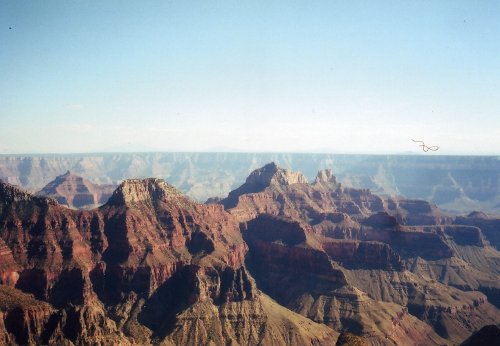
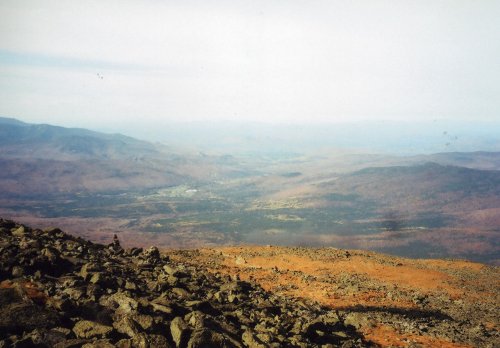
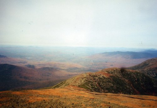
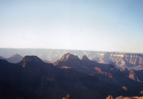 Here are a couple of pictures of the North Rim of the Grand Canyon
I walked the round trip to the Lodge twice today for meals and found it a little easier than yesterday but the 8,200 foot elevation is still hard on me. I have never done very well at altitudes over 6-8,000 feet but as I age it is becoming even more of a problem. Saw a Camp-Inn Teardrop from CO in the Campground, my first Teardrop sighting on this trip, and spent a few minutes visiting with the owners. I had breakfast at the Lodge, good but expensive, as well as dinner; long on presentation, short on quantity and very expensive. The North Rim is as scenic as the South but not as many scenic view points concentrated in a small area - you need to drive further along the Rim on the North to get to the scenic spots. I'm very glad that I decided to included it on this trip, I don't know when or if I'll get another chance except to specifically target it for a visit - it is quite a ways off the beaten path.
4 Sep: N. Rim Grand Canyon to Flagstaff, AZ
Roads:AZ67, ALT US 89, US89, ALT AZ89/US66/Milton Rd, Forest Meadows, Beulah Blvd/ALT AZ89
Distance: 205 miles
Camp: Wal*Mart
Route
Today I drove through Jacob Lake again, Cameron to Flagstaff, AZ. I got an early start today, sun up, even though it will be a short day. Stopped for breakfast at Jacobs Lake, AZ and then stopped at Starbucks in Flagstaff, AZ to use their WIFI. This time I was successful but I still could not use AT & T, the store had AT & T but the signal was very weak and the staff suggested that I use the signal from the Motel next-door. Checked email, updated BlueHighways.org, a site that I'm posting Road information to, and sent a couple emails to tell people that I was on schedule. The Wal*Mart in Flagstaff, AZ had no problem with me parking overnight but there is a City Ordinance prohibiting "camping" in their lot. I just love the freedom that we now have in the USA to use our personal property as we see fit - there are no personal property freedoms any more, it is all controlled by the State. I did a walk in the afternoon to old down-town Flagstaff and the Railroad Station. The 4-5 blocks of "old town" have been Californicated and you wouldn't know you were in AZ if you didn't see a sign telling you different. Dinner was at a Mexican Restaurant on my return walk that was more CalMex than AzMex and certainly not MexMex - not overly expensive but more than in Reno, NV.
5 Sep: Flagstaff to Wickenburg, AZ
Roads:Beulah Blvd/ALT AZ89, ALT AZ89, AZ89, US93 & City Streets
Distance: 165 miles
Camp: Steve's
Route
Drove through Sedona, Cottonwood, Jerome, Congress to Wickenburg. I went back to Starbucks this morning and finished updating my postings to BlueHighways.org and checked email. Today was a short drive but through some spectacular mountain climbs and descents with marvelous scenery. I had previously driven parts of this route but it was 30 years or more ago and I had forgotten how great a drive it was. I stopped in Cottonwood, AZ for breakfast but still got to Wickenburg by 11:45 and then drove around lost for 30 minutes. I made the unforgivable error of asking a local for directions and was sent even further off track. I should have simply backtracked on my prepared directions and determined where I had missed a turn; this was probably a good lesson this early in the trip. Steve and I exchanged life stories all afternoon; the last time we had seen each other was probably in 1962. We graduated High School together in 1960 and then went to different Universities until the Fall of 1961 when I transferred back to the University of Arizona. I then had dinner with he and his wife Lise, originally from Boston but now a naturalized Arizonian.
6 Sep: Wickenburg to (Near) Forest Lakes, AZ
Roads: City Streets, US93, US60, AZ74, Lake Pleasant Rd/Lake Pleasant Parkway'83rd Av, Thunderbird Rd, City Streets, 51st AV, AZ101, Shea Blvd, AZ87 & AZ260
Distance: 198 miles
Camp: Canyon Point Campground
Route
I drove through Wickenburg, Peoria, Glendale, Phoenix, Scottsdale, Fountain Hills & Payson to near Forest Lakes, AZ. I had breakfast at Steve's and we then did a driving tour of Wickenburg. We went past his office that is in a small strip mall on US60 and then past some of the new industry in Wickenburg. For many years one of the bigger contributors to Wickenburg's economy was dude ranches, these have been replaced somewhat by drug/alcohol/eating rehabilitation clinics. When we got back we shot a few games of pool on a table that Steve has on his back patio, something I haven't done since the late 70's. I played very badly and my left shoulder gave me a lot of trouble when I extended my arm. I've had a problem for the past couple of months now with it - maybe bursitis pain or maybe just old age? I got a little lost when I tried to find Roger's (former workmate) place but turned around and approached from the south, my normal approach direction some 25 years ago. He was not home and another workmate that was to join us for dinner did not answer his phone. I waited for about and hour and Roger arrived but had problems hosting me for the weekend as planned. We visited for about an hour and I decided that it was best for me to get out of the Valley of the Sun and into the high country of AZ. I picked up dinner at the Safeway in Payson and then got very lucky to obtain the last camping space at Canyon Point Campground. As I drove out of the Phoenix area it was 109 degrees, here it is in the 70s with tonight low to be in the mid 40s.
7 Sep: (Near) Forest Lakes, AZ to Socorro, NM

Roads: AZ260, US60/California St
Distance: 249 miles
Camp: Wal*Mart
Route
The towns today were Heber, Show Low & Springerville, AZ then Quemado, Pie Town, Magdalena to Socorro, NM. I stopped at Sassy's Cafe for breakfast in Heber, AZ for breakfast - very good food and helpful staff. I had only my Atlas and was looking for a NM state map to help me make a decision regarding my route, I had originally planned on going through Gallop to Clovis, NM but was considering going through Socorro. No one could tell me for sure if I could do it and avoid I-25 but I thought I'd take the chance. I stopped again in Pie Town, NM and had some pie and coffee and was able to look at a detailed road map of NM. There was no way I could get to East US60 from Socorro but when I stopped in Magdalena I was able to get a Socorro City map and see that I could reach NM380 by using NM1.The town of Lincoln, NM is about 1/2 State Monument and I could see why there was a Lincoln County War with Billy the Kid involved. It is beautiful grazing land and is still used for that purpose with some orchards and truck farming near the river. Sadly I saw no aliens or any flying saucers around Roswell as I drove through.
8 Sep: Socorro, NM to Amarillo, TX

Roads: US60/California St/Old State Rd/NM1, NM1, US380/US70, US70/US285/US70, US60, Farm Road 2590, TX335 & City Streets
Distance: 363 miles
Camp: Wal*Mart
Route
I passed through Luis Lopez, San Antonio, Carizozo, Lincoln, Roswell, Portales & Clovis, NM then Hereford to Amarillo, TX. When I walked into a Socorro restaurant at about 5:30 am for breakfast there were 3 "old guys" siting in a booth drinking coffee. The one facing me as I walked in said "You didn't shave this morning." I replied with "It has been more than a couple of days." He then said "sit down" which I did and we had a long conversation while I ate breakfast. He was retired from the City of Socorro, 83 years old, World War II vet and loved to talk. The other two guys didn't say much, probably did not understand much English because the first guy would speak to them in Spanish.
9 Sep: Amarillo to Palo Duro Canyon, TX
Roads: City Streets, TX335, Farm Road 2590, US60, US87, TX217 & P5
Distance: 34 miles
Camp: Hackberry Campground
Route
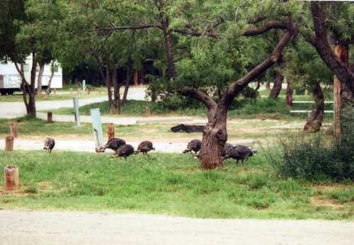 My camp in the Canyon where this turkey flock came to visit me both days that I was in the Park.
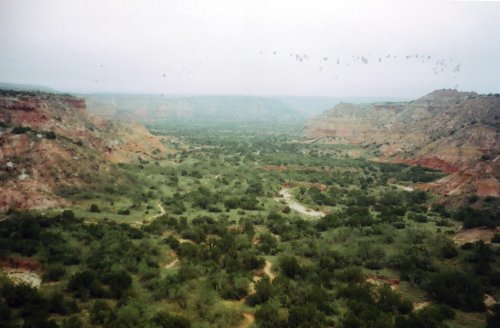
Today I was in Amarillo & Canyon, TX to Palo Duro Canyon State Park. I couldn't remember where the Starbucks was in Amarillo, TX (I had looked it up once but did not write it down) but the Customer Service Associate at Wal*Mart looked it up and got directions for me. I stopped there this morning and got caught up on BlueHighways.org, checked email and sent a couple notifying people that I was on schedule. Don had sent me a Warning about the possible landfall of hurricane Ike. There was heavy fog as I drove to Canyon, TX where I stopped for breakfast. I then went on to Palo Duro State Park where my Golden Age card did nothing to reduce the $24/day charges. I got set up for camp, unhitched and the went for a hike along a short trail that follow the river through the canyon. Texans call this the Grand Canyon of Texas; it is geologically impressive but doesn't hold a candle to the Grand Canyon in AZ.
10 Sep: Palo Duro Canyon, TX
Roads: P5, TX217, US87, TX217, Farm Road 1541, Amarillo City Streets, Farm Road 1541, TX217 & P5
Distance: 73 miles Unhitched
Camp: Hackberry Campground
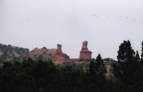
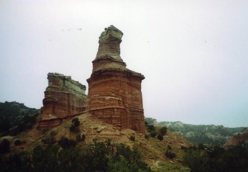
 This is the Lighthouse Rock formation that is the signature feature of Palo Duro Canyon from a couple of different angles and distances as I approached it. Then looking up the canyon along the trail that I have hiked to reach the base of the Lighthouse formation. Lastly the steep climb up the water eroded base of the formation.
I was up at 6:00 am as usual but because of changing to Central Time and being on the western edge of that zone I didn't have sunrise until 7:15. I had decided to hike to the signature rock formation in the Park, The Lighthouse, and wanted to do so before it got too hot so I did the first 30 minutes of the hike in moonlight. The total distance was 5.96 miles and most of it was moderate up and down with some soft sand. However, the final .2 miles was a very steep water eroded climb of some 400 feet; tough going on both the climb and decent. After I finished the hike I went into Canyon, TX for breakfast and to pick up dinner plus brandy. I found that Canyon is in a dry county so I got to do some sightseeing in Amarillo while searching for a liquor store. I got back in time to be visited once again by a flock of turkeys that seem to live in the campground. Yesterday they came through about 50 yards from my trailer, today some of them were within 30 feet. Later in the day a new camper came in with a pop-up trailer and after getting set up he came over and we had a long visit. He is retired on disability and had been on a trip to Alaska and was now on his way home in Alabama.
11 Sep: Palo Duro Canyon to Abilene, TX
Roads: P5, TX217, Farm Road 1541, Farm Road 1151, Farm Road 1258, TX207, TX86, TX70, US380, US83/US277 & City Streets
Distance: 310 miles
Camp: Wal*Mart
Route
I went through Silverton, Turkey, Matador, Spur, Jayton, Aspermont to Abilene, TX. I had either condensation or some light rain on the car and trailer when I got up this morning. By the time I turned onto Farm Road 1151 it was a misty rain and I then drove into hard rain by the time I got to Silverton and stopped for breakfast. I had hard rain from there to Jayton with the roads awash in 2 or 3 places and I may have been lucky to get through before the roads were closed - the rivers and streams were roiling with flood waters. I was confused by the road signs as I entered Abilene and got off the correct road to go back and get on Business US83; I stopped to get get directions to Wal*Mart and found that I was close to both Wal*Mart and Starbucks. The Starbucks had a WIFI AT & T connection and I found an email from Don that said he could not host me for the weekend. Hurricane Ike was causing problems in Huston where he had to help family members and there was going to be massive traffic problems around San Antonio created by people escaping from the coast. I called him and left a message that I would be moving on toward the East and would try and call again. This made for another trip route revision and I'll try to make camping reservations tomorrow while I have WIFI available at Starbucks.
12 Sep: Abilene, TX to Ardmore, OK

Roads: City Streets, TX351, TX6/US180, US283, TX79, TX25, Farm Road 174, TX148, US82, US81, US70 & City Streets
Distance: 253 miles
Camp: Wal*Mart
Route
Today's drive took me through Abilene, Albany, Thockmorton & Archer City, TX then Waurika & Ardmore, OK. I stopped in Albany, TX for breakfast and then in Archer City, the boyhood and current home of Larry McMurtry. He has a book store which contains thousands of used books and one of the employees said they have people come from all over the world to look for rare books. I don't think I need to point out that Archer City is not on any well beaten path so you really have to want to go there. The land to the NE of Abilene is rolling hills that are much more interesting to drive through than the Panhandle that I have been in. I couldn't make reservations on-line for the campground that I wanted, they require reservations be made 4 days prior to arrival, so I'll take my chances. I have never made reservations for a Corps of Engineering campsite and have always managed to get one so I hope that luck holds. I've developed two travel rules so far on this trip: 1)Treat all directions from "locals" with some doubt, however, directions to the closest Wal*Mart are generally reliable 2)Never expect your trip "plan", the one you put together at home, to work out as planned.
13 Sep: Ardmore, OK to Mena, AR

Roads: City Streets/US77, US77, US70, US271, OK1/AR88 & US71
Distance: 236 miles
Camp: Wal*Mart
Route
I drove through Madill, Durant, (Near) Hugo, & Tuskahoma, OK then to Mena, AR via the Talimena Trail. I stopped for breakfast in Madill, OK; nothing special except the very cheap price, the cheapest so far on this trip. I also noticed a practice that seems to be common to TX and South OK, they serve your coffee with the spoon sticking up in the cup. I believe that I first saw this in Canyon, TX and it has been served that way every morning since then. I had light rain and fog for the Trail (OK1/AR88) so it was not as scenic as it could have been, I did see the 13% grades that I had been warned of and I like the new trailer much better on these kind of days. I'm also very happy that after driving for 2 days in the rain I haven't found any signs of leakage anywhere in the trailer - my other trailer would have had a LOT of water in it by now. I then got very heavy rain and strong winds from Ike starting around 4:00 pm until late in the night.
14 Sep: Mena to (Near) Crystal Springs, AR
Roads: US71, US270 & County Road
Distance: 73 miles
Camp: Crystal Springs Campground
Route
I went through Acorn, "Y" City, Joplin & Crystal City, AR. Mena, AR got 3.3" of rain yesterday with most of it coming after I parked. It was raining very hard when I went to sleep but had quit by around midnight when I woke up. I had all the doors and vent closed because the wind was also rocking the trailer a bit but I can not keep it sealed up for a long time - I run out of fresh air. It was also still rather warm but my interior fan allowed me to sleep in comfort until I woke up and was able to open up the vent. There was a tree blocking truck traffic on US 270 about 10 miles west of Crystal City and then another one on the County Road leading to the Campground but I was able to get around both of them. The Campground was with out power and showers Sep 14 through mid-morning of the 16th so I wasn't charged any fee for that time, and had the whole campground almost to myself. I had a very nice site up away from the lake under pine, oak and hickory but I saw one tree down not too far away and hoped that the winds were over. It is much cooler here than it was in Amarillo, Abilene & Ardmore - the downside is that there are no restaurants open nearby because of the power outage or their normal days to close.
15 - 20 Sep: (Near) Crystal Springs, AR
Roads: County Roads, US270 & Hot Springs, AR City Streets
Distance: 240 miles unhitched
Camp: Crystal Springs Campground
I drove through Crystal Springs, Royal, Hot Springs and Joplin to get breakfast and dinner because the power outage continued to disrupt restaurant operations around the Crystal Springs area. Power was restored in Hot Springs and Joplin first and I was able to get breakfast at Mountain Harbour Resort or in Hot Springs. After power came back on I could get dinner in Crystal Springs (a couple of miles) and breakfast at Mountain Harbour Resort or in Royal (both about 8 miles one way). I also went into Hot Springs, AR to use internet and get my car washed during this period but washed my trailer in the campground. There was the obligatory sign, as you enter Hot Springs, that identifies it as being the boyhood home of President William Jefferson Clinton.The power and showers was available once again on the 16th at the Campground and it filled up Fri night - I liked it better early in the week. The majority of my time was devoted to reading and enjoying some wonderful weather - not to hot and humid with a gentle breeze. I did have one very interesting neighbour; he and his wife were camping in one of the old VW "Pop-up Vans". He was retired Navy, maybe 15+ years, and they had lived in that van for the past 10 years. Mostly in Mexico but also all of the Central American countries. They come back into the USA every 6 months and then go back into Mexico on a new 6 months visa, they were on their way to Big Bend National Park for a few weeks until temperatures cooled down a little along the West Coast of Mexico.
21 Sep: (Near) Crystal Springs, AR to Jena, LA

Roads: County Road, US270, AR7/US167, El Dorado City Streets, US167, LA8, US165, Pollock City Streets, US165, LA8 & US84
Distance: 313 miles
Camp: Wal*Mart
Route
Today's drive was through Crystal Springs, Hot Springs, Arkadelphia, Camden & El Dorado, AR then Ruston, Winnfield, Pollock to Jena, LA. I stopped in El Dorado,AR and Pollock, LA to talk Teardrops with a couple of builders that I had "met" on a Teardrop Forum. Jeff in El Dorado was building a 5x10 that looked almost big enough that I could put my teardrop inside his. Other than the size it is a conventional teardrop built on a modified RV trailer frame but like many home built teardrops it appears to be "overbuilt", that is it is much heavier built than necessary. The tear being built by Jack, in Pollock at Gator Teardrops, is also 5x10 but does not give the same impression of massiveness. His tear is sided with camouflage cloth and epoxy and although it has that "different" look it is conventional in most other respects. Both of these teardrops have full galleys and the other comforts of home including air. It was very foggy this morning when I went through Hot Springs where I stopped at Starbucks again to check email and update BulueHighways. The drive to Pollock on US167 took about an hour longer than I had estimated because of construction from the LA state line to LA8 (no sign showing where to turn when going south). There was also a convoy of Carnival trucks that had started in Conway, AR that delayed traffic even more (I saw them again at Wal*Mart in Andalusia, AL). I had originally planned on going through Fort Polk, LA (near Pollock and where I did my Army Basic Training) however the Fort web site indicated that it was an active post and it was doubtful that I would be allowed to enter. It would have also been a waste of time for me to try to find my old barracks, they have all been torn down and new barracks constructed since my time there. The entire day was a drive through twin walls of trees with logging seeming to be the primary economic activity. I find it somewhat of a paradox that there seems to be a LOT of logging all through the Southeast and the environmental tree huggers don't seem to mind it, yet the get almost hysterical about logging in the West.
22 Sep: Jena, LA to Andalusia, AL

Roads: US84
Distance: 367 miles
Camp: Wal*Mart
Route
I went through three states today, thousands of "love-bugs" and Ferriday, LA then Natchez, Laurel & (Near) Waynesboro, MS to Grove Hill, Evergreen & Andalusia, AL. I was up very early this morning but was lucky to find a breakfast place at 6:00 am and by the time I had finished the fog had mostly cleared. The eastern part of LA and most of AL had some cotton and soy-bean field that broke up the continuous line of trees but MS was much like yesterday with logging predominating. My other reminder of MS was a rock that was thrown up by a roadside mower that I caught almost dead center in my windshield which left a "bullet hole" appearance where it shattered the glass. Another lingering memory of MS & AL will be the "love-bugs" (2 bugs about 1/2" long with black wings and yellowish guts that are joined at the abdomen; they face away from each other yet are able to fly in one direction while so joined). By the time I got to River Falls, AL, where I stopped for gas, my windshield was so covered with bug splats that I could hardly see - they were also very difficult to wash off (the locals suggested that I use a wet "dryer sheet", those sheets you add to the dryer). My front licence plate was not readable through all the black wings that were pasted to it by bug guts and what had once been a red car now looked like it had a black front grill.
23 Sep: Andalusia, AL to (Near) Chattahoochee, FL

Roads: US84, AL55/AL331, US90 & Booster Club Rd
Distance: 135 miles
Camp: Eastbank Campground, GA
Route
A short day but I was still in 3 states; through Florala, AL then De Funiak Springs, Marianna and Chattahoochee, FL to camp in GA. I had breakfast in Andalusia (at Huddle House, I think this is a chain and I also ate at another near St. Joe State Park last year) which I didn't find to be very good but it was recommended as the best place for an early breakfast. I usually ask the Wal*Mart Greeter where there is a good early morning breakfast place and so far this practice has resulted in about a 70-30 score for getting good recommendations. I went past the highest point in Florida near Florala, AL - a towering 345'. It also seems that N. Flordia has more farms near US90 than I saw along all of US84 but the logging trucks continue. It was a short day even with a couple of stops, once at an ATM and then in Chattahoochee to get directions to the Campground (I saw no signs). After getting set up in the campground I went to visit a neighbour to ask about what I should buy for the fire ants that I had been warned about when I checked in. We had a short visit and they then gave me enough ant poison to spread around the trailer jack and the tires (where the trailer was in contact with the ground). When I went into Chattahoochee for dinner I spent about a 1/2 hour washing the "love-bugs" off the front of my car. When I returned to camp I got my laundry done at the camp bath house; this is the second Corps of Engineers Campground that I have stayed in that has had washing machines and dryers (Mark Twain last year was the other).
24 Sep: (Near) Chattahoochee, FL
Roads: Booster Club Rd & US90
Distance: 17 miles unhitched
Camp: Eastbank Campground, GA
I drove into Chattahoochee for breakfast and dinner but beyond than that today was rest time. While I was at breakfast I asked the restaurant owner if I could access the free WIFI available at the next door motel from her restaurant - she said she didn't know. I tried to do so from the parking lot and found that it was password protected and went back inside to use the owner computer. I had misunderstood what she had told me earlier when she said that if I couldn't access it I could use her internet - she still had the service but her computer was "toast" and I mine can not use dial-up. To solve the problem she called the motel and got their password and I went back to the parking lot and got an Internet connection.
25 Sep: (Near) Chattahoochee, FL to Vidalia, GA

Roads: Booster Club Rd, GA97 Spur, GA97, GA112 & US280
Distance: 204 miles
Camp: Wal*Mart
Route
Today I went through Bainbridge, Vada, Camilla, Sylvester, Ashburn, Rochelle, McRae to Vidalia, GA. I stopped in Hopeful, Ga where the commercial part of town was made up of a General Store/Restaurant and a peanut processing plant. There were a lots of peanuts awaiting processing all along GA97 & GA112, this seems to be harvest season for them. Then I got into "Sweet Onion Country" as I approached Vidalia, GA but saw no onions, it is past harvest for them and all the field were bare at this time of the year. I heard a lot of talk on the radio today about gas shortages in the Atlanta area; so far I haven't had any problems geting regular (85 or 87 octane) but have noticed at my last two gas stops that there was no Premium available. It clouded up this afternoon for the first time in about a week and I got a few sprinkles after I got parked.
26 Sep: Vidalia, GA to N. Charleston, SC

Roads: US280, US1, GA292, US280, GA119, Guyton, GA City Streets, GA119/SC119, US321, SC336, SC462, SC170, Beaufort, SC City Streets, US21, US17, SC165, SC642 & N. Charleston, SC City Streets
Distance: 305 miles
Camp: Sherry's
Route
I drove through Lyons, Manassas, Pembroke & Guyton, GA then Garnett, Tillman, Ridgeland, Beaufort, Jacksonboro, (near) Ravenel to N. Charleston, SC. I stopped in Claxton, GA for breakfast and then Guyton, GA & Beaufort, SC for visits at a winery and Teardrop builder. I had a difficult time finding Butterduck Winery in Guyton, GA - had to ask for directions 3 times before I got there. When I did find it I bought some extra sweet scuppernong wine, a desert wine made from the scuppernong grape that is native to the North American Continent (I came across it in my reading and had to try it). I then had even more trouble finding Retro Traveler Trailers in Beaufort, SC. After trying to follow my prepared directions I called their shop for directions to get directions and talked to the woman receptionist. She could not give me any street names, all her directions were made with reference to stores that I would see - that was a problem however, I could not see what she was refering to because of trees. I pulled into a drive way leading into a shopping area to turn around and found one of the referenced stores by accident, I could not see it from the street. I had about an hour visit once I found their shop and saw 3-4 teardrops or "standies" that were under construction. Their primary business is the restoration of old Airstream Trailers or similar type trailers - they had a large lot that was full of trailers that were awaiting the owners decisions on what they wanted done. Finding places today went from bad to worse when I got into N. Charleston - the street signs were so small, or obscured by trees, that I could not read them while driving at 35-45 mph and watching traffic. I had 3 turns to make and had to stop 3 times to get directions to find them because of this. It was a really tough day to find my stopping points! However, the fried oyster dinner at the Crab Shack with Sherry and family made it worth wile.
27 -28 Sep: N. Charleston, SC
Roads: City Streets
Distance:15 miles unhitched
Camp: Sherry's
I had not seen Sherry since we both left Bulgaria in 1998 and I had met her Bulgarian/Turkish husband only once while we were there. She now has two boys, got her Masters at N. Arizona University, taught on the Navajo Indian Reservation and then moved back "home" to SC. We did tourist stuff on Sat. with a visit to Fort Sumter which included a ferry ride out to the island. We also drove around through the old down-town and I could see places that had been described by John Jakes or James Reasoner in their novels. Then on Sun. Sherry and family needed to go to Columbia to see her parents and pick up a car, go to church and visit. While they were away I went out to breakfast, got my trailer washed, updated BlueHighways and did other computer stuff.
29 Sep: N. Charleston, SC to Clayton, GA
Roads: City Streets, SC642, SC165, Alt US17, US78, US178, US178/US76, US178, US64, NC106/GA246 & GA15/US23/441
Distance: 309 miles
Camp: Wal*Mart
Route
I drove through N. Charleston, Summerville, Orangeburg, North, Saluda, Greenwood, Honea Path & Anderson, SC then Rosman, NC to Clayton GA. I stopped in Sommerville for breakfast and soon after that was back into peanut country once again with a few cotton fields. I entered the mountain foothills after going through Liberty with US178 and US64 being very steep in places and twisty almost everywhere. There were a lot of 15-20 mph turns but the trailer pulled like a dream, no feeling that it was pushing me as I braked on the downhill turns. There were a lot of mountain resorts along US64 and the area look like it would be an expensive tourist area during summer vacation season. There were a lot of what looked like weekend and vacation homes also. Fall is just begining, here and there I can see a splash of color.
30 Sep: Clayton, GA to Asheville, NC

Roads: US23/441, US76, GA60, TN68, TN165, TN360, US411, TN72, US129, Foothill Parkway, US321, US441, Blue Ridge Parkway & US25
Distance: 322 miles
Camp: Wal*Mart
Route
I drove through Young Harris, Blairville & Mineral Bluff, GA then Copperhill, Tellico Plains, Tallasee, Townsen & Pigeon Forge, TN to Asheville, NC - ALL mountain driving with an average of about 40 mph, making for a long day. I did avoid going through Gattlinburg, TN by taking the Great Smoky National Park cut-off and then through the Park on US441. The Fall colors are starting to show with some of the trees (20-30%) turning along the Blue Ridge. I think that the percent of trees that have turned is mostly due to the mix of tree type, some trees turn sooner than others and here on the Blue Ridge the show is just beginning. I got to Ashville, NC just before a very strong thunderstorm that included hail that was about pea size, no damage done but I was was very concerned that the trailer would look like someone had at it with a ball-peen hammer.
1 Oct: Asheville, NC to Roanoke, VA

Roads: US25 & Blue Ridge Parkway (Detour #1: US70, TN9, Old Fort Road, US70 & TN80 Detour #2: US321 & Boone, NC City Streets)
Distance: 297 miles
Camp:Wal*Mart
Route
The first detour from the Blue Ridge Parkway was my solution to get around a closed section of the Parkway; the designated detour route would have me driving I-40. I did follow the designated detour for the second closing. It was not quite as mountainous today as yesterday and the Parkway reminded me of Natchez Trace with farms and homes closer to the road. Yesterdays portion of the Parkway was more like the Skyline Drive in VA that I drove last year but I had views of range upon range of mountains vs the Shenandoah Valley. Neither the Skyline or yesterdays drive had any farms or development near the road. The weather was much more like Fall today with cool winds and lots of falling leaves.
2 Oct: Ranoke to Culpeper, VA
Roads: US220, Blue Ridge Parkway, Skyline National Park, US211, US522 & BUS US15/29
Distance: 238 miles
Camp: Wal*Mart
Route
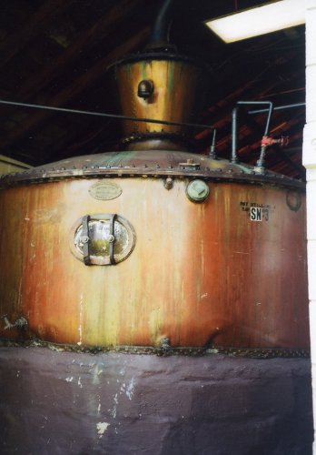 This is the 2000 gallon copper pot still, constructed in 1930, that is used for the first distillation of Virginia Lightning a 100 proof White Lightning.
I had breakfast in Ranoke and then drove drove through Sperryville, VA and pasts Culpeper to Belmont Farm Distillery for a short tour and explanation of the distillery process. There I bought a bottle of Virginia Lightning, corn whiskey that is the smoothest 100 proof "booze" that I have ever had pass my lips. A very small world experience happened also at the distillery - the owners son is a private plane pilot flying out of the Reno, NV airport. Prior to that I saw my first black bear on the Skyline Parkway as well as a number of deer. The last 10 miles of the Skyline was under construction with fresh gravel that left my car and trailer a real mess.
3 Oct: Culpeper to Alexandria, VARoads: BUS US15/29, US15/29, US29, US50, VA7 & City Streets
Distance: 72 miles
Camp: Mark & Laurie's
Route
I stopped at a recommended "dinner", somewhat lost before I found it, in Warrenton, VA for breakfast and then stopped again for over an hour at Manasas National Park to go through the museum and walk the grounds. Once again I was surprised by the reality of the ground that I walked vs what John Jakes & James Reasoner have written about the Manasas Battle. This is where "Stonewall" Jackson got his famous nickname and from what I have read I was expecting a HILL. What I found was a slight rise in the land with a small dip where General Bee died and was quoted as saying "There stands General Jackson like a stonewall" and then another slight rise. There was a lot of stop and go traffic on US15/29, US29 & VA7 between Culpepper and Alexandria as well as within the city when I got there. This is probably the traffic conditions that I will deal with for the next couple of weeks while in the Northeast. I missed one of my turns, but considering the trouble I had finding stops on my day into N. Charleston, SC today was a piece of cake. Laurie had left a key for me and once I got my trailer unhitched and car parked it was shower and relax time until she and Mark got home from work. This was the first time that I had seen either of them since Bulgaria, they married after we all left there but both of them have been in some "stan" country or Georgia (the country not the state since then). They now both work for NGOs that are head-quartered in Washington DC and since they have only been back in the USA for a little over 6 months they are still going through culture shock - it seems that Mark has adapted faster than Laurie.
4-5 Oct: Alexandria, VA
Roads: None
Distance: None
Camp: Mark & Laurie's
I did a little walking up and down "Art on the Avenue", about a 10 block section of Alexandria that was blocked off for an art fair, food vendors and music. Mark, Laurie & I also met Ken (Bulgaria Country Director while we were there) at a coffee shop and had a face to face visit for the first time in 10+ years. On Sunday, Kerry and Shasha (the first time that I have seen them since Bulgaria also) joined us for Brunch. They now live in MD not far from Washington DC; he works for the Government investigating fraud and she is in law school. That is really an accomplishment for her, she married Kerry in Bulgaria and came to the USA knowing very little English. Earlier in the day I washed off the dirt that my trailer had picked up on the Skyline, the car is still somewhat of a mess but it shows more on the trailer.
6 Oct: Alexandria, VA to Millville, NJ

Roads: City Streets, US1, VA218, US301, US301/50, US50, MD/DE404, US9 & NJ47
Distance: 269 miles
Camp: Wal*Mart
Route
I went through Alexandria, Falmouth & Owen, VA then (near) Annapolis, Chesapeake Bay Bridge & (near) Wye Mills, MD to Georgetown & Lewes, DE then Cape May & Millville, NJ. This was my first 4 states in one day; I'll probably have some more while in the northeast. I made very slow progress while driving through Alexandria and along US1 but VA218 became more rural. I was somewhat concerned that I had only gone 50 miles in the first 2 hours because I had a reservation for the Cape May-Lewes Ferry. I then made much better time on US50 and MD/DE404 except for a construction area near Georgetown, DE. I arrived about an hour before the ferry was to leave but had only averaged 36 mph so it was best that I had not stopped for breakfast; I got a late lunch at the Ferry Terminal. I was impressed by all the agriculture that I saw in MD, DE and NJ - the southern part of NJ can still support the Garden State nickname.
There were roadside farm stands in all three states plus I saw a lot of standing corn ready for harvest as well as a lot of diaries. The Chesapeake Bay Bridge and Ferry crossings of the Chesapeake and Delaware Bays were nothing special except for the $42 that I spent to do so. However, it was the most direct way for me to go through MD, DE, NJ and avoid Interstate Highways - I'm very glad that I selected the route.
7 Oct: Melville, NJ to Kingston, NY

Roads: N47, N552, N555, N540, N557, N54, US206, CR533, US1, CR522, NJ27, CR518, US206, US202/206, US209 & US9W
Distance:232 miles
Camp: Wal*Mart
Route
I drove through E. Vineland, Buena, White Horse, Clarksville, Kingston, Somerville, Netcong & Newton, NJ then Milford, PA to Port Jervis & Kingston, NY. I had breakfast in Millville, NJ at a Bob Evens Restaurant, one of the few chain restaurant that I actually like. Today was another relatively short day but my average speed for the past 2 days has been around 35 mph so I'm driving longer and covering less distance. I crossed the Delaware River on the Milford-Montague Toll Bridge ($1.50) that was under construction and reduced to one lane and controlled by a traffic light. I was first in line while it was red and upon it turning green I proceeded to cross the bridge but had a truck blocking my way when I got across. So now I'm stopped once again with line of traffic behind me. One of the construction guys walked over to me and asked if I had a red or green light when I started across - I told him that it had turned green and he said that the signal had changed in error and just sit tight until they could unload the truck. I noticed something again today when I ask for direction help. When I ask how to get to a specific road ie "How do I get to US206?" the usual answer is "Where do you want to go?". I then usually respond that I want to go to US206! But I'm finally getting a little smarter in asking the question and have started to say "How do I get to town XXXXX on US206?" I pick Town XXXX not very far from where I am currently so the chances of getting directions other than by way of US206 are reduced, if I don't do that I'll almost always get directions to get on some Interstate Highway.
8 Oct: Kingston, NY to Lincoln, RI

Roads: US9W, NY199, US44, CT219, CT20, CT75, CT140/159/140, CT74, CT195, US44, US1, RI15, RI146 & City Streets
Distance: 186 miles
Camp: Nora & Ray's
Route
I drove through Kingston, Red Hook, Lafeyetteville & Millerton, NY then Canaan, New Hartford, Granby, Windsor Locks, Rockville, Mansfield, CT to Providence & Lincoln, RI. After I found a breakfast cafe in Kingston I went over the Kingston-Rhinecliff Bridge ($1.50) that crosses the Hudson River. I continue to have slow average speeds and the Fall colors are increasing as I move further north. I had partial fog this morning near the Hudson Valley but it cleared by the time I reached some scenic views in western CT. I did not intend on going through Providence, RI but missed the turn onto RI15 from US44 so I got to see the State Capital building as well as much of down-town. I had to stop once more to get directions to Nora's but I was on the correct road when I did so - my prepared directions were correct but again I had problems with road signs.
9 Oct: Lincoln, RI
Roads: None
Distance: None
Camp: Nora & Ray's
I visited Nora last year, prior to her marriage to Ray, while she was living in an apartment in Pawtucket, RI. They now have a very nice house in Lincoln, RI (an administrative town that is made up of a number of villages: somewhat like what Iwake City was in Japan). They both teach at schools that are located in MA but have a shorter commute than previously and can do so together. We had another good visit and Nora cooked up a couple great meals for me - I really start to miss the large salads that I have almost every night at home when I'm on the road and lots of vegetables as well. We did a short drive (in RI that is almost a given) to a local winery and farm stand where they bought some fruit wines and apples - I simply enjoyed someone else driving and I could look around even more. Once again I was able to use my hosts computer to update BluHighways and check email.
10 Oct: Lincoln, RI to Arcadia National Park, ME

Roads: RI/MA146, MA16, MA27, MA62, MA28, MA/NH125, US202, ME137, US1, ME3 & Park Roads
Distance: 369 miles
Camp: Blackwood Campground
Route
I drove through Lincoln City Streets, Uxbridge, Sherborn, Maynard, Concord & Haverhill, MA then Rochester, NH to Sanford, Gray, Lewiston, Augusta, Albion, Belfast, Ellsworth & Otter Creek, ME. It was my longest mileage day so far but part of them were because of being lost 3 times - road sign designations are not the best in MA. The extra miles were not that much but the time lost just added to a VERY long day because my average speed continues to be low. If I had my druthers I wouldn't try to cover much more than 250 miles per day while in the NE but I can't always do that or I sometimes make a mistake - today was probably the latter. The positive aspect of today's route was the increasing Fall colors that have become much better in ME. There were more portions of road that were not walls of trees and allowed for longer sight lines of rolling hills with vivid colors. I was even able to see the mountain ranges to the north in ME's Highland Region. My camp is in a heavily forested campground of pine with a few birch and the occasional oak and maple. The Park is mountainous by NE standards and now very colorful. The ME radio station that I happened to be listening to said that central ME was now at peak Fall color so my timing has been perfect. I went to an Otter Creek Restaurant (the closest available) for dinner of oyster stew that was very good but also very expensive.
11-13 Oct: Arcadia National Park, ME
Roads: Park Roads, Bar Harbour City Streets, ME3 & ME 233
Distance: 107 miles unhitched
Camp: Blackwood Campground
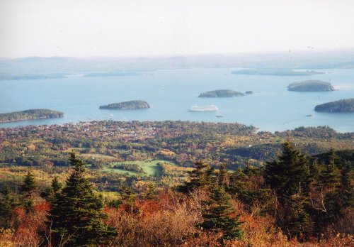
 Two pictures taken from Cadillac Mountain showing some of the great fall colors and Bar Harbor in the first one with a cruise ship at anchor.
I drove around Arcadia N. P. on the Loop Road and up to Cadillac Mountain (1,530' and still cold at 9:00 am) where I had a clear day and great view of the Fall colors which were wonderful. I also made two trips every day into Bar Harbour for breakfast and dinner. The meals at Poncho Villa Restaurant were good (the coffee was excellent) but very expensive by Reno standards for a Mexican Restaurant. Much the same can be said of the Arcadia Cafe; good food but expensive - something that I guess I should expect in a tourist town. The nights were cold but days were in the 60's with rain during the night of the 12th and some in the morning of the 13th. I found out that the Village Green (village square) had free WIFI and I used it twice to check or send email.
14 Oct: Arcadia National Park, ME to Twin Mountain, NH

Roads: Park Roads, ME3, US1, ALT US1, US2/ME100/US2, ME113, US302, ME16, US302, Base Road, US302 & US3
Distance: 277 miles
Camp: Ammonoosuc Campground
Route
I drove through Bar Harbour, Ellsworth, Bangor, Bethel & Fryeburg, ME then Redstone, Glenn & Fabyon to Twin Mountain, NH. The Fall colors were great all across ME. The northern section of ME113 was spectacular much like driving inside a Kaleidoscope with leaves overhead, on each side and covering the very narrow road. However, NH has had a lot of leaf fall and they consider the season over - most of the restaurants in Twin Mountain were closed with only one open for breakfast and another for dinner. My campground was open but in the process of winterizing the trailers that park there all year; it is not much for the $24/day but does have a shower with hot water. I stopped at the Mt. Washington Cog Railway base station today and bought the last ticket for the 10:00 am train tomorrow and can only hope for a clear day. My speeds were up a little today because I was going through more rural areas most of the day.
15 Oct: Twin Mountain, NH
Roads: US3, US302 & Base Road
Distance: 30 miles unhitched
Camp: Ammonoosuc Campground
I managed to beat the odds and had a very atypical day at the top of Mt. Washington, NH. The summit (6,288') has fog an average of 237 days/year and some of the worst weather of any reporting weather station in the US. I got a clear, sunny day with temps in the low 60s and gentle breezes. I went up via the Cog Railway which was billed by P T Barnum as The Second Best Show on Earth. Upon completion of the trip I tried to access WIFI from the parking lot but had a very weak signal; but I made inquiry in Twin Mountain and was able to connect at a "closed for the season" highway information booth on US302. From that location I updated BlueHighways and checked email once again.
16 Oct: Twin Mountain, NH to Rutland, VT

Roads: US3, US302, NH142, NH18, NH116/112/116, NH10, US5/Truck Route US4, US4 & City Streets
Distance: 121 miles
Camp: Ron's
Route
My luck changed today as I drove in rain through Pierce Bridge, Bethlehem, Franconia, Easton, Benton, Havehill, Hanover & West Lebonon, NH to Woodstock, Killington & Rutland, VT. The rain slack off later in the afternoon and while Ron (in Bulgaria with me and in Japan at the same time) was at work I spent time on his computer mapping out my route for the closing portion of this Quest. I also got an oil change since I was now over 7,000 miles into the trip and didn't know where I might be able to get one later - I use Mobil 1 synthetic oil which I am confident is good for 10,000 miles but I usually change at about 7,500.
17-18 Oct: Rutland, VT
Roads: City Streets
Distance: 11 miles unhitched
Camp: Ron's
On the 17th Ron and I walked down-town and had breakfast and the he took me to a barber shop so I could get a haircut and beard trim. The barber "skined" my head and my face but both will grow out again - a hazard of travel. Later that day I also went to a coin operated laundry in town and got that domestic duty taken care of, I was out of clean clothes and it was a high priority. On the 18th we went through the Rutland Farmers Market and picked up some items which included a small pie - added ice cream from a store on the way back home and had a great dinner. Lounging around, visiting and some TV was the order of both days. I stopped and saw Ron last year but it was good to see him once again.
19 Oct: Rutland, VT to Elmira Heights, NY
Roads: City Streets, US4, NY29, NY30, US20, NY14 & NY64
Distance: 321 miles
Camp: Wal*Mart
Route
I went through Rutland, VT then Whitehall, Schuylerville, Johnstown, Esperance, Geneva, Watkins Glen to Elmira Heights, NY. I stopped at a small "Mom & Pop" restaurant on US4 for breakfast that was only fair but very cheap compared to what I have been finding in the NE. The view along Seneca Lake on NY 14 was the best Fall colors of the day; there has been a lot of leaf fall along my route today. The west side of Seneca Lake has winery after winery - these are among the many that bottle what are known collectively as Finger Lake wines. My Atlas did not show NY64, I had no state map and missed the road sign - not a lot of time lost or miles added just another challenge to find Wal*Mart today.
20 Oct: Elmira Heights, NY to Middlefield, OH

Roads: NY64, NY/PA14, US6, Detour: (PA155, PA446 & PA46), US6/19, US322, OH528 & OH87
Distance: 330 miles
Camp: Wal*Mart
Route
I went through Elmira Heights/Elmira, NY then Troy, Warren, Corry, Meadville & Jamestown, PA to Colebrook, Huntsburg & Middlefield, OH. The detour was due to a closed section of US6, that took me through more farming country and past a small oil refinery. I was surprised by the size of the oil refinery at Warren, Pa but it is the largest town in the area of the first oil wells in the USA. However, it looks very old and at some point will be shut down with very little chance that a new refinery will go up in it's place.The area around Middlefield, OH has a large Amish population and the Wal*Mart has covered parking for 8 horse and buggy, I had more than 30 come by where I was parked. It was very cold last night and this morning - 25 degrees at around 7:00 am when I got on the road.
21 Oct: Middlefield, OH to Sturgis, MI

Roads: OH87, OH44, OH303, US20, US6, US6/24, US6 & IN9/MI66
Distance: 274 miles
Camp: Wal*Mart
Route
Traveled through Sholersville, Peninsula, Hinckley, Belden, Wakeman, Norwalk, Fremont, Napoleon & (near) Ridgeville Corners, OH to Kendallville, IN & Sturgis, MI. I got rain again last night starting around midnight with light rain continuing in the morning. I had breakfast in Middlefield and started driving under heavy clouds and some rain. The early part of the day was through a mix or urban/suburban and a scattering of farms. The farther west I went the more farm land I drove through and the clearer the sky became - not a cloud in the sky when I arrived in Sturgis, MI. However, it was as cold in the afternoon as it had been when I got up. The Fall colors have been very spotty; some trees are still green, others are bare and a few are at full color.
22 Oct: Sturgis to Petoskey, MI
Roads: MI66, US12, MI40, MI222, MI County37, MI County42, MI179, MI43, MI66 & US131
Distance: 317 miles
Camp: Wal*Mart
Route
I drove through Sturgis, Marcellus, Paw Paw, Allegan, Hastings, Ionia, Kalkaska to Petoskey, MI. it wasn't much colder this morning than it was when I went to bed last night; maybe 33 degrees. the Fall colors continue to be spotty in MI with some bright reds, purple, gold and yellows but also bare trees. The early part of the drive was convoluted but it kept me in rural areas and I dodged the urban areas of Battle Creek, Kalamazoo, Grand Rapids & Lansing. Christmas tree harvest was under-way near Lake City, MI and a lot of corn remains to be harvested all through OH, IN & MI; I thought it would have been cut by now.
23 Oct 23: Petoskey, MI to Antigo, WI

Roads: US131, US31, MI119, MI County81, Mackinac Bridge, US2, US8/141/8, WI47, US45 & WI64
Distance: 331 miles
Camp: Wal*Mart
Route
I went through Petoskey, Pleasant View, Mackinac City, Escanaba & Norway, MI to Pemline, Monico & Antigo, WI. The temperature this morning was around freezing with frost on the windshield. I took MI county roads from Petoskey, MI to Macinac Bridge where I arrived just after sun rise (8:00 am here on the western edge of the Eastern Time Zone). I wanted to get a good view of the Bridge and the Lakes to the east and west and was not disappointed - the Bridge was worth the $4.50 toll. The Fall colors in Upper MI are almost all gone and there is a lot more pine than hardwood. I crossed into Central Time a few miles west of Escanaba, MI which got me to Antigo, WI a little after 2:00 pm but I had been on the road for 7 hours and considered it enough for the day.
24 Oct: Antigo, WI to Cambridge, MN

Roads: WI64, US45/WI29/US45, WI22/US10/WI22, WI21, Necedah City Streets, WI80/173/80, WI13, US8 & MN95
Distance: 414 miles
Camp: Wal*Mart
Route
I drove through Antigo, Wittenberg, (near) Clintonville, Waupaco, Wautoma, Necedah, Pittsville, Marshfield, Medford, Ladysmith & Cameron, WI then Taylors Falls, North Branch to Cambridge, MN. If I had just been crossing WI I would have stayed on US8, but I wanted to visit Camp-Inn Teardrops in Necedah, WI. While there the entire factory crew came out to look over my trailer and we discovered that the torsion axles were coming out of the axle housing mounted to the trailer. They have moved out 2 1/2 -3" on each side and it has me worried that they will continue to pull out and a wheel will fall off - not a good prospect. I will revise the remainder of my trip to get the trailer back to the builder in CA as quickly as I can; watching the gap closely as I go along. I'm not sure what can be done to fix the problem short of new axles. I had rain almost all day with only the last few miles in MN being rain free. This has been my longest mileage day so far but with an increased average speed my driving time was less than the day into Arcadia Park.
25 Oct: Cambridge, MN to Aberdeen, SD

Roads: MN95, MN23, Detour: (US10, MN County29 & MN15), MN55, MN23, MN9 & US12
Distance: 276 miles
Camp: Wal*Mart
Route
I went through Cambridge, Princeton, St. Cloud, New London, Benson & Ortonville, MN to Aberdeen, SD; the detour was due to a closed bridge across the Mississippi in St. Cloud. I had moderate headwinds for most of today with a forecast of a storm coming tonight and tomorrow; even the moderate winds were a drag on gas mileage because they were directly from the left front. The axle problem does not appear to be any worse after about 500 miles; however the roads were reasonable smooth and the NE USA roads had been much worse were the problem developed. I have driven out of Fall colors but feel that I have successfully obtained item #1 of MY Quest - see the Fall colors throughout the USA!
26 Oct: Aberdeen, SD to Miles City, MT

Roads: US12, US83, US212 & MT59
Distance: 475 miles
Camp: Wal*Mart
Route
I drove through Aberdeen, Bowdie, Forest City, Faith, Mud Butte & Belle Fourche, SD across WY to Broadus & Miles City, MT. Saw hundreds of antelope as soon as I entered WY and then scores of deer and antelope in MT. I had very strong winds starting around 3:00 am and drove into a headwind of 20-40 mph all day - it killed my mpg big time. I can not see any additional separation of the axles and have hope that I'm going to get the trailer back to CA - it is a constant worry however and I'm checking them frequently. I accomplished item #2 of MY Quest today when I crossed through WY - I have crossed through the 21 states during this trip that I did not go through in 2007. During the two trips and over a 19 month time span I have driven through all the "lower 48" states while towing a Teardrop trailer (different ones on each trip). The longer mileage was to escape the storm and get the trailer to Mike in CA. I had considered stopping in Sturgis or Spearfish, SD but it will not make the axle problem any worse to drive the same distance in one day or take two.
27 Oct: Miles City to Great Falls, MT
Roads: MT59, MT200/US87, Bypass US87 North, 15th St Bridge/US87, Truck Route Signs & MT200/ NW Bypass
Distance: 314 miles
Camp: Wal*Mart
Route
I went through Miles City, Jordan, Lewiston, Stanford to Great Falls, MT. I had my coldest night so far last night in Miles City (19 degrees) and woke up with my condensed breath frozen to the inside of my trailer windows. The winds finally quit today and temperatures are up in the 60s. The axle problem seems no worse but I'm still focused on getting the trailer to Northern CA as soon as I can. I saw a lot of wheat yesterday and today all across MT. It was also the first day of deer season yesterday so I've been seeing lots of hunters and still a lot of deer but only a couple of bucks. The antelope were even more in evidence, I've seen hundreds of them since crossing into WY.
28 Oct: Great Falls, MT to Lewiston, ID

Roads: MT200/NW Bypass/Vaughn Rd/MT200, W. Riverside Dr/E. Broadway/Business US12, Brooks St/US12, US12, US12/93, US12 & City Streets
Distance: 376 miles
Camp: Wal*Mart
Route
Today I drove through Great Falls, Vaughn, Lincoln, Milltown & Lolo, MT to Lewiston, ID. The night time low went up to around 40 degrees last night and I was once again very comfortable - it seems that my 20 degree sleeping bag rating is about the limit for comfort without keeping my clothes on; maybe good to 10 degrees if fully clothed. I got back into some Fall colors again today but they are on a green background of pine forests. The most striking were what I think are Larch trees in the Bitterroot Range that looked like yellow candle flames scattered across the hills. I had the most visitors to my Teardrop in a Wal*Mart parking lot last night with three different people stopping by to ask questions or say hello. One of the had a homebuilt 5x9" Teardrop and a lot of advice for me concerning my torsion axles, however he did admit that he didn't know anything about torsion axles and had leaf springs on his. I entered Pacific Time today and gained the additional hour that offered. I stopped in Lincoln, MT for breakfast this morning; a town that I camped in both summers of 1990 & 1991 while on multi week cross-country bicycle tours. Although the town does not have a sign advising the fact, this was also the home of Theodore John Kaczynski, known as the Unabomber. In 1971, he moved to a remote cabin in Lincoln, MT and from 1978 to 1995, Kaczynski sent 16 bombs to targets including universities and airlines, killing three people and injuring 23. Note: I didn't see him while I was there either year.
29 Oct: Lewiston, ID to Bend, OR

Roads: City Streets, US12, WA125/OR11, US395, US26, US97 & City Streets
Distance: 399 miles
Camp: Wal*Mart
Route
I drove through Lewiston, ID then Walla Walla, WA to Pendleton, Mount Vernon, Prineville, Redmond & Bend, OR. The road signs were poor for WA125 in Wall Walla, WA and for the junction of OR11 to US395 in Pendleton - not as bad as the signs in MA but still not good. There was NO sign at all for US26 at the junction with US395. I snagged something with my trailer wiring and pulled the plug out from the tow vehicle today and destroyed the trailer plug - something else for the builder to fix and maybe reposition to get higher from the ground. I was surprised by the scenery available along US395 and US26 in OR although it was mared somewhat by smoke for a forest fire in the area. More Fall colors but mostly the yellows of cottonwood and the dark browns/purple of oaks with some more Larch(?) burning brightly within the pines.
30 Oct: Bend, OR to Shingletown, CA

Roads: City Streets, US97, OR39/CA139, CA County91, CA299, CA89 & CA44
Distance: 307 miles
Camp: Lassenview Teardrops
Route
I went through Bend & Altamont, OR to Lookout, Bieber, Old Station & Shingletown, CA. A lot of today's route was the same as 18 months ago but I was seeing it in the Fall rather than the early summer. I had clouds building all day and got a few sprinkles after stopping in Shingletown for late lunch. Mike's roommate, Shannon, did most of the trailer parking for me after I got to Lassenview and I flopped on the couch until Mike got home. Mike, my Teardrop builder, had no idea what had caused the axle failure but he will keep the trailer until he gets a replacement to get it fixed as well as the wiring issue. Therefore, the trailer stays in Shingletown until sometime in the Spring when it has been repaired and the snow melts enough for me to go get it.
31 Oct: Shingletown, CA to Sparks, NV
Roads: CA44, CA36, US395 & City Streets
Distance: 165 miles unhitched
Camp: Sparks Motel
Route
I drove through Shingletown and Old Station again to Susanville, CA and then Reno, NV. This completed My 2008 Quest. I had some problems and a few disappointments but the Quest was well worth the time, cost and effort. I mentioned two of my Quest goals as I completed them; the final one was to visit old and new friends along the way. My disappointments were that I did not get to see everyone that I had planned on seeing and having to reduce the trip somewhat because of the axle problems. I hope to see you next time!