Minden to Minden to Minden (ITG3)
June 8 to June 29, 2009
The Summary
Miles with Dapple (My Scion xB): 5,705
Miles with Casa del Panza (My Teardrop) in tow: 5,705
Interstate Highway Miles: None
Duration of the trip:22 days
Nights in Casa del Panza: 21
States Visited: 12
Total Trip

8 Jun: Reno to Bodega Bay, CA

Roads: Reno city streets, US395, NV88/CA88, CA88/49, CA88, CA12, CA12/99, CA12, (Fairfield) Pennsylvania Av/Cordellia Rd, Lopes Rd, Red Top Rd, CA12, CA12/29, CA12/ 121,CA121, CA116, (Petaluma) Washington/Bodega Av, Valley Ford Rd & CA1
Distance: 274 miles
Camp: Porto Bodega Marina
Route
We have had 8 days of rain in Reno and I was hoping for some clear weather. When I got up early, as I always do for the start of a trip, it was clear as it could be and I was grateful. There was very little snow pack along CA88, the days of rain have washed it all away. This is a big contrast with what it looked like in 1996 when I drove it to meet some of the OFC that were doing a Iowa 150 Bicycle Ride across the country. I think it was later in the summer of 2003 when I drove my MINI over CA88 so there was no snow then either. I stopped in Jackson, CA for breakfast but even with the stop I could see that I was going to be at my planned camp very early in the day. Therefore, I changed my plans and decided to go to Bodega Bay, CA. That is one of the things that I like about my mode of travel these last 3-4 years, no reservations made and changes can be made along the way. I know that I need to be in Vancouver on Jun 11th because I told Jody I would be there on that date but I can stop wherever and whenever I want between now and then. It was very, very green from Petaluma, CA all the way to the coast. I saw lots of dairy cows, beef, sheep and chickens and orchards along the way with a lot of roadside stands selling cherries. It was still a nice day in Bodega Bay with some haze but still sunny with a breeze. There was a restaurant just across the street from the camp so I was set for the evening.
9 Jun: Bodega Bay to Crescent City, CA
Roads: CA1 & US101
Distance: 313 miles
Camp: Wal*Mart
Route
I woke up just as the sky was starting to get a little pink to the sound of seals barking somewhere in the bay - could not see them but sure could hear them. There was low clouds all along the coast in the early morning but no rain and only a couple small patches of fog. I stopped for gas in Jenner, CA but there was nothing open for breakfast. That I got at Point Arena; a small hole-in-the-wall place that served a decent omelette, the coffee was good but the price was VERY expensive. It was about 140 miles from Bodega Bay to Legget, where CA1 junctions with US101, and it took me over 4 hours with the two stops. The coastal C1 is more twisty and hilly north of San Francisco than south if that is possible. There were also 4-5 stretches that had road construction restricted to one lane and I stopped at all but one of them. While stopped about 20 miles north of Fort Bragg a woman that had been following me all that way (while I followed a logging truck) rushed up to my car and trailer to tell me "You have the classiest rig I've ever see, and the first camping trailer ever that has personalized license plates." Highway US101 from the junction to Crescent City was an improvement over the coast road but still had a lot of sections that were up, down and twisty. Crescent City, CA has a city ordinance against parking in Wal*Mart lots overnight, they even have the street beside Wal*Mart posted. I asked to stay, was told about the ordinance, and made it through the night without and police.
10 Jun: Crescent City, CA to Redmond, OR

Roads: US101, US199, OR99, OR234, OR62, OR230, OR138 & US97
Distance:279
Camp: Wal*Mart
Route
It started a very light mist when I got up this morning and turned into a light rain as I climbed through the mountains to Grants Pass, OR. I stopped for breakfast near the junction of US199 and OR99 and it was raining hard when I was ready to leave. It was then an off and on rain all day to Redmond, OR. Not a lot of scenery until I got onto OR62 but after the turn off to Crater Lake I was doing the reverse of a route that I drove in 2007. From the best that I could see because of occasional rain showers not a lot has changed. I knew that Bend, OR had an ordinance against parking so I thought I would try them this time. They also have an ordinance but much fewer signs in the parking lot than Crescent City; I didn't see them until I had asked permission to park and was told about the ordinance. Stayed the rainy night and was not bothered about parking. While I'm thinking about it, I'll list those towns that I have stayed at Wal*Marts that have city ordinances that prohibit parking - Monticello, NY, Missoula, MT, Flagstaff, AZ, Crescent City, CA, Bend, OR and Redmond, OR.
11 Jun: Redmond, OR to Vancouver, WA

Roads: US97, US197, WA14, (Vancouver) SE164th Av/NE164th Av/NE162nd Av, NE Ward Rd, WA500, NE137th AV, NE99th ST Distance: 189 miles
Camp: Jody's
Route
I was up at 5:00 am with the sun just starting to lighten the sky. Stopped for gas and breakfast in Madras, OR but that didn't take long so I knew I'd be in Vancouver early in the day. I had told Jody that I would be there sometime between mid-morning and mid-afternoon. There were a lot of mesas, cattle range and some hay fields along the way north in OR. Then came the big surprise of a deep canyon with the Deschutes River flowing through it and the little town of Maupin, OR. I found Jody's apartment easily enough but had to park on the street because there was no visitor parking allowed within the apartment complex. Her daughter was there when I arrived but she was dropping of her son for Jody to babysit and left soon thereafter. It was then time to visit and get caught up on our lives since the 2007 trip when I stopped and saw her in Battle Ground, WA. The only other thing that I accomplished was to post my trip log to BlueHighways.org and get some sleep.
12 Jun: Vancouver, WA
Roads: None
Distance: None
Camp: Jody's
I slept late this morning, late for me that is, and didn't get up until six. Had some coffee to get the eyes open and then went out and washed the white-walls on my xB. The driving in the rain had them looking a mess plus when they were mounted by Big O they used some black "goo" of some kind along the tire/wheel rim and it has leaked out and left black lines down through the white-wall. Jody and I then had breakfast and more talk. I told her I wanted to have a nice fish dinner so she drove us to a place in Vancouver where I had a planked salmon that was quite good. I bought a desert to take home with us and we had that with a bottle of scuppernong wing that I got in GA last fall.
13 Jun: Vancouver to Othello, WA
Roads: NE 130th AV, WA500, NE 137th AV, NE Fourth Plain Blv,NE 162nd AV/NE164th AV/SE 164th AV, WA14, WA142, Bickleton Rd, WA241, WA24/(Othello) S Broadway AV & E Main ST
Distance: 236 miles
Camp: Wal*Mart
Route
I had an early breakfast at Jody's and caught very light traffic getting out of Vancouver. Jody's place is on the eastern side of town and that helps get in and out easily but the traffic was heavy yesterday when we went to dinner. The scenery along WA142 and Bickleton Rd was cattle range land with one deep canyon to descend and then climb out again. There were a lot of crops around Mobton, WA (a high plains after crossing a mountain range); what I took to be hops, cherries, apples, grapes, hay and grains.
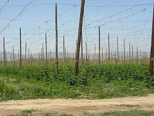 I thought this was hops growing but I don't think I have ever seen them before.
This heavy agriculture area continued through to Sunnyside until I crossed another mountain range where I was back in cattle rang land again. It was semi-desert all along WA24 north of the Hanford Site (probably the worst atomic waste site in the US) but then more crops around Othello - lots of apples. I had two retired school buses full of Mexican farm workers park next to me at Wal*Mart where they went in to do their weeks shopping. It has gotten a lot hotter here compared to the first part of my trip, it must be in the low 90s but I do have a wind blowing.
14 Jun: Othello, WA to Ponderay, ID

Roads: (Othello) E Main St, WA17, US2, WA231, WA291, US2, Division St/US2/US95 & (Ponderay) Kootenai Cut-off
Distance: 266 miles
Camp: Wal*Mart
Route
Today was one of missed turns. The road markings for turns onto US2/US395 from WA 291 were not there or I missed them; I realized my mistake and checked my Spokane City Map to see what the Street name for US2/US395 was. I then drove west looking for US2/US395/Division St and found the Street but no US Highway turn designations; there were plenty of signs indicating US2/US395 along the street after I had turned. The second missed turn was my own fault in Sandpoint, ID where I needed to be in the left lane and was block by heavy traffic. The early part of the day was a drive through hay and wheat fields or cattle range land. The most scenic was WA231 that took me north through a canyon but then when I turned onto WA291 it became lots of pine trees of Spokane development. If I had not needed gas I would have stayed on WA231 until WA292, US395 to Deer Park the east to join US2; maybe on another trip. there was a Mexican Restaurant across the road from the Ponderay, ID Wal*Mart that I went to for dinner. I found something on their menu that I had to try; spinach tamales and spinach enchiladas. I had never seen this before, nor even heard of them before, but found them to be excellent - I think it was the sauce that did the trick. Maybe I will give it a try at home.
15 Jun: Ponderay, ID to Great Falls, MT

Roads: (Ponderay) Kootenai Cut-off, ID200/MT200, MT56, US2, US89, US89/MT200 & Frontage Rd/NW By-Pass/3rd St.
Distance: 387 miles
Camp: Wal*Mart
Route
There was alight rain when I got up at 5:00am that turned to into hard rain showers all the way to Libby, MT. I chose to take MT200 rather than US2 because I wanted to cover the same route that we took on the bicycling cross-country. I particularly wanted to see the roadside signs for Hop, E. Hope & Beyond Hope Idaho; I was disappointed however because they are no longer there as I remembered them. A lot has changed over the past 19 years and this is just one of many. Libby, MT has also changed a lot in that time with lots of new buildings and a lot more people - it has been Californicated like so much of western MT. I stopped there and had breakfast and then got out of the rain soon after I started east again. It stayed clear until near sundown when we got some light showers once again. I was finally driven inside my trailer to keep dry, prior to that time I had been entertaining "visitors". I've stopped at the Great Falls Wal*Mart three times so far and every time I have had more visitors stop by there than any of my other Wal*Mart stops - not sure why that is.
16 Jun: Great Falls, MT to Gillette, WY

Roads: 3rd Street/Truck Route, US87/15th St Bridge, River Dr/57th St, MT200/US87, MT200, Mt59, Mt59/US212, MT59/WY59, Little Powder River RD/Gurley Av, 12th St & Douglas Highway/WY59
Distance: 462 miles
Camp: Wal*Mart
Route
It was raining when I got up this morning and continued steadily until after I had stopped in Winnett, MT for breakfast and gas. I then got scattered showers for the rest of the day with some of them very hard for short periods. From Great Falls to Miles City I was retracing my route of last fall in reverse but it was very different because of the rain, very green and no deer or antelope. I got to Miles City early in the day and decided to make today a longer day, the plan was for a very long day tomorrow. I had forgotten about the Judith Mountains in the middle of MT but was impressed by their beauty when I crossed through them today. The "badlands" along Hwy 59 on both sides of the MT & WY border for about 25 miles are also impressive.
17 Jun: Gillette, WY to North Platte, NE

Roads: Douglas Highway/WY59, WY450, US85, US85/US18, US85, US26, US26/NE61, US30 & US83
Distance: 434 miles
Camp: Wal*Mart
Route
I changed my planned stopping point once again after arriving in Scottsbluff early in the day and finding a Wal*Mart parking lot that was a bare as it could be with no restaurants nearby. I would also like to get to Minden as early as I can tomorrow and get my trailer washed up at the least, maybe the car some too. Today I saw a lot of antelope during the morning from Gillette to the junction with US18. I also saw the largest herd of buffalo that I have ever seen just north of the junction of WY59 & WY450. The scenery from Newcastle, WY south was mostly farms with corn maybe 8" tall, mature wheat that will soon be harvested cattle range and feed lots. I have been very lucky with the mild temperatures, although a lot of rain, that I have had so far but today it has caught up with me and I have high temperatures and VERY high humidity. This is probably what I have to look forward to until I get to NM.
18 Jun: North Platte to Minden, NE
Roads: US83, US30 & NE10
Distance: 113 miles
Camp: Pioneer Village
Route
I'm very glad that I did the last two long days. I had a short day today but didn't take into consideration the change to Central Time. I crossed the Time Zone yesterday just west of North Platte but didn't realize it until this morning when I went to a breakfast place that I knew was going to open at 6:00 am. I got there a few minutes before 6:00 (my time) and saw people enter while I waited; it then dawned on me that my time was wrong and it was almost 7:00 am. But even with the time change I was in Minden early enough to get the car and trailer washed, checked in, trailer/umbrella set-up and car white-walls washed all by 11:00 am. That made it time to kick back and rest for 2 1/2 days. I had some light rain in North Platte during the night but it didn't cool thing down much at all - I ran my fan almost all night. The Minden area had heavy thunderstorms with big hail and a tornado that did some damage near Aurora, NE (about 50 miles for Minden). There were about a dozen teardrops in the campground when I got here but more are coming in all day. In the mid-afternoon I took advantage of the WIFI that was available in the Pioneer Village Motel/Campground Office and got my trip log caught up on BluHighways.org.
19-20 Jun: Minden, NE
Roads: None
Distance: None
Camp: Pioneer Village
We had a big thunderstorm the morning of the 19th around 1:00 am. I woke up and jumped outside in my shorts to take my umbrella down and get the trailer doors closed but it was raining hard by that time so I left my chair out in it. There is some sun but it is still overcast and will take all day to dry out my chair. Then it started to sprinkle again at 9:30 so the wet chair went inside and the umbrella stayed down. I walked up to the 'square" in Minden and found that the one cafe there had changed hands and was a lunch/dinner place now. However, there is a new espresso place on the northwest corner of the square that has a very limited breakfast menu. I then went to the library and bought two books for a $1 donation so I would have something to read during the next few days. There were more trailers coming in all day so on my return to camp I walked through and checked out all the teardrops that were there and then did the same thing after I had dinner at the Pioneer Village restaurant. I have had a lot of great comments on my trailer and how good the "rig" (car and trailer look). The sky cleared off enough to dry my chair but I'm putting it inside tonight to keep it that way.
I went to the espresso place for breakfast on the 20th and use their free WIFI to update my trip log and check e-mail. I did two more passes through the campground looking at teardrops and visiting with a few people that I had met before at the previous ITGs or with new participants - it is becoming more a mid-west gathering than International. The morning sky was blood red - red sky in morning, sailor take warning. I started to rain again around 1:00 pm and was cloudy and or raining the rest of the day.
21 Jun: Minden, NE to Woodward, OK

Roads: US6/34, US183, KS383, US36, US283, US50, 14th Av, Wyatt Earp Blvd, US283 & US270/183
Distance: 347 miles
Camp: Wal*Mart
Route
The rain had stopped by the time I got up, finished my morning toilet and was hitched up to travel. I got a breakfast recommendation from Jim and his Dad for a restaurant in Norton, KS that I acted upon and by the time I left there I saw clear sky the remainder of the day. I had planned on staying in Dodge City but got there soon, bought some water and continued south. I could have avoided the Dodge City Wal*Mart by staying on US283 but thought I would see it as a possible future stop. I ran into a detour of US283 in Wakeeney, KS that would have put me on the I-70 so I created my own detour to the north of the downtown area and then went west and south again to rejoin US283. I had a light wind from the west most of the day through KS and OK but when I got to Woodward it was 97 degrees, humid and the breeze did little good. There was some thunder heads build up late in the day but they broke up without and rain to drop the heat plus the humidity stayed high - uncomfortable.
22 Jun: Woodward, OK to Brownwood, TX

Roads: US270/183, OK34, US60, US283, US283/183, US183, US377/67 & US67
Distance: 367 miles
Camp: Wal*Mart
Route
Yesterday afternoon and last night was HOT but this morning when I stopped in Cheyenne, OK for breakfast and gas it was worse - there was no breeze. It was dead calm, not a leaf stirring, still very humid and the temperature in the 80s. Those same conditions remained with me all day but I was running my car air conditioning while on the road it was when I stopped that I felt it once again. I saw a lot of oil wells along US283 or US183 all the way from KS but it seems the farther south I drive the fewer of them are pumping. It is just a guess but from what I have seen there can't be much more than 10-20% of the wells producing any oil. In TX today it has been even worse in some of the oil fields that I drove past, there were no pumps working. I saw a lot of tall brush and short trees for scenery with some slight hills and the occasional river. The Red River was running red because of the red banks, the Brazos River was also running red, and the Clear Fork of the Brazos was a muddy brown. I was very surprised to see mountains in Oklahoma, these were not just hills but true mountains that I think were the Quartz Mountains near Altus, OK. I need to explore them more sometime in the future!
23 Jun: Brownwood to Boerne, TX
Roads: US67, US377, US377/87, US87, US290, Farm Road 1376, US87, Johns Road to Tapatio Springs
Distance: 160 miles
Camp: Capri & Don's
Route
The parking spot that I selected yesterday proved to be one of my poorest choices. It's had one positive aspect - there was a tree and it provided some shade for me while I sat in the drivers seat and wrote in my journal. There were more negatives however; it was extremely hot and humid (maybe 98 on both scales), there was a big rig that parked nearby and ran his diesel engine/air conditioning all night and the tree was the night roost to a flock of Great-tailed Grackles.
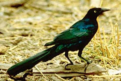 This is the 'dirty bird' that makes a mockery of the Texas slogan 'Don't Mess with Texas'. This is the male of the species, I didn't see any females they are more brown in color.
These are dirty, dirty birds! They covered the drivers side of my car from mid-hood to just past the drivers door with more bird crap than you can imagine in one short evening. The early part of the drive today was through country like yesterday but I then got into "Hill Country" at Fredricksburg, TX. The last 35 miles through Luckenbach, TX on Farm Road 1376 was such hills with lots of live oaks and "trophy ranches"; ranches where the owner is spoken of as being "all hat, no cows" or they are 10' high fenced exotic game animal ranches. I stopped at the County Court House and asked the deputy sheriff that was working the reception desk where I might park because the friend that I was visiting said there was no place to park at his home. The deputy asked me what the address was and when I told him he said "That are has a lot of parking restrictions." He then pointed to a travel agency across the street from the Court House and said "I can't tell you to park over there but I can tell you that the agency is closed and looking of a new lease." He then wanted to see my "rig" and we went out to look over the trailer before I re-parked at the agency. I call Don from there and he came down to meet me and lead me back to his place where I could park at the Tapatio Springs Resort Hotel parking lot. There was no place to park at his home; it is built on the side of a hill with 3 levels progressing down from the garage up at top where there is a very narrow street. It is a very expensive home in a very exclusive golf resort development. The entire home is decorated with Indian pots, kachinas, rugs and Indian dresses - very nicely done, in good taste but obviously very expensive. Don took me back into Boerne (pronounced Born-E) for dinner at his favorite Mexican Restaurant (owned by Iranians) where they also had spinach enchilada on the menu (I had the chicken ones that Dan recommended). I did get my laundry done and caught up on my trip log while he was getting a hair cut but the rest of the time was all devoted to talk. We graduated from High School together in 1960 and then were room-mates at University of Arizona for 3 semesters until we graduated in 1965. We both then went our own ways until Don as one of the Reunion organizers found me through the Internet in 2008 and we re-established contact. So this was our first face to face meeting in 44 years. Who would have thought that the first thing he would say to me was "You have gotten old."
24 Jun: Boerne, TX
Roads: None
Distance: None
Camp: Tapatio Springs Resort Hotel
Don and I went back to Boerne for some breakfast and then toured the area. Both he and his wife have family "roots" in this area that go back to the 1800s with ancestors buried in small country cemeteries. One of Don's hobbies and interest has been genealogy and that is probably also what got him interested in finding Douglas High School Classmates. We devoted most of the day to talking about our lives and sharing a few Vietnam war stories (only a relative few of our High School Class served there). For dinner he took me over a part of my route for tomorrow to a restaurant in Bandera, TX where I had some more Mexican Food. I wanted to get an early start on my drive as always and didn't want Don to be getting up when I did to take me to me trailer so I stayed this night at the Resort Hotel.
25 Jun: Boerne to Odessa, TX
Roads: Tapatio Springs Resort, Deep Hollow Dr, TX46, TX16, Farm Road 337, TX55, US277, US190, Farm Road 305/US385 & Loop 338
Distance: 340 miles
Camp: Wal*Mart
Route
I was up and on the road before sun-up this morning knowing that I would not be missing anything along the route that I had covered yesterday. I stopped at the same restaurant in Bandera for breakfast and by the time I had finished the sun was up. I followed the "Hill Country Trail" until TX55 and then the "Texas Pecos Trail" along Farm Road 305 during the day. I had ridden a short segment of the "Hill Country Trail" in 1987 as part of a bicycle tour across Texas. The land became flatter and flatter as I drove north and west and the vegetation was more of the desert than the wetter east although there has been a serious lack of rain around Boerne this year. Once I joined US 190 I saw lots of oil wells again but very few were pumping, however, I did see a new well being drilled just south of Odessa. This was once one of the biggest oil fields in the USA, the Permian Basin Oil Filed. It is still probably the largest producer within the USA but there are a vast number of wells that are not producing. I got a good cloud build up after I arrived in Odessa which gave me some shade and I had some breeze but it was 98 degrees and still 96 at 6:00 pm. Because of these conditions I'm going to change my planned trip and combine the next 4 days into only 2 and try to get out of the heat. I will stop at Carlsbad Caverns tomorrow but will then continue on to Socorro, NM and then the following day go to Page, AZ.
26 Jun: Odessa TX to Socorro, NM

Roads: Loop 338, TX302, US285, Farm Road 652, US62/180, NM7, US62/180, US285, US70/380, US380 & NM1/US60
Distance: 417 miles
Camp: Wal*Mart
Route
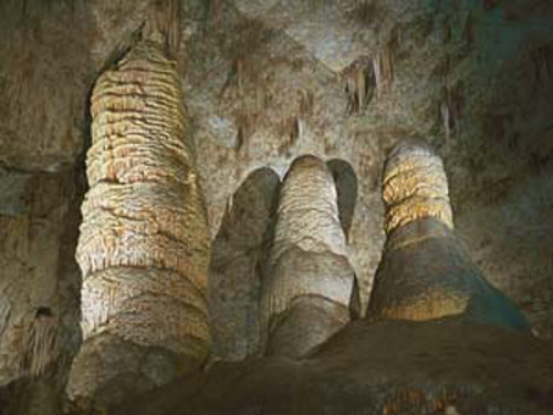

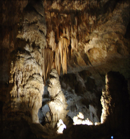
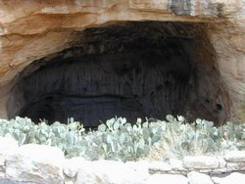 The natural entrance to the caverns where I started the self guided walking tour, I took the elevator to get out.
The three above are the most often photographed stalactites and stalagmites in the Cavern. I didn't take the pictures, I've copied them from the web.
I had to run the fan in my trailer all night again last night trying to keep it cool enough to get some sleep, it was not as bad as Brownwood, TX but it was very uncomfortable. I did the self guided walking tour of Carlsbad Caverns and was glad that I didn't take a jacket as was suggested on the web site, it was in the mid 50s with the humidity in the high 80s to low 90s and I was wet by the time I got out. I read all the trail-side explanations about the Caverns formation and it is a very good thing that it was formed as long ago as it was.
In the forming process of the cavern itself there had to have been massive quantities of C02 released into the atmosphere and if that were to be happening now the environmentalist would be lobbying to shut the process or at least tax it in some way. I saw a Teardrop Trailer with Texas plate on it when I came out of the cavern but there was no one around. I had been in the cavern longer than I anticipated but still got to Socorro by 4:30 where it was somewhat cooler at 88 degrees with clouds and a good breeze. I had dinner at the restaurant across the street from where I was parked and will go there for breakfast in the morning - maybe see my "friends" from last fall. My skipping Carlsbad as a camping stop was a good decision, it is cooler here now than it was there at noon.
27 Jun: Socorro, NM to Page, AZ

Roads: US60, NM36, NM53, NM602/US491, NM264/AZ264, US160 & US89
Distance: 446 miles
Camp: Wal*Mart
Route
I didn't find my friends of last fall at the restaurant this morning but had two new ones join me, they were both wearing Vietnam ball caps whereas last fall my friends were WWII vets (what is this with vets at this restaurant at 5:30 am?). The two new breakfast guests were interested in my Teardrop and will to listen to my travel tales while I ate. There seems to have been a lot more rain to the north and west of Fence Lake, NM than what I have seen since Boerne, TX. This even continued across the Navajo reservation and it appeared that Page, AZ had a good rain within the last 24 hours. I got a good rain in Socorro last night that did a lot to wash off the deposits that I had received in Brownwood, TX. The last two days have been more driving than I usually like to do but it has been worth it to reach some cooler weather. Most of AZ 264 was really rough and somewhat along the way today I lost the tongue jack cover (this was a plastic cover over the gears that raise and lower the jack). Here in Page at 5:00 pm it was 85 degrees with low humidity and a breeze - great weather compared to what I have been having.
28 Jun: Page, AZ to Tonopah, NV

Roads: US89, UT14, UT130,UT56/NV319, US93, NV318/375, NV375, US6 & US95/6
Distance: 419 miles
Camp: Ramada Inn
Route
Last night was the coolest that I have had in the trailer in a long time, I ran the fan only a short time to get to sleep and then woke up to cold and shut it off. However, that was last night and in Page the outlook for Rachel, NV (my planned stop) is not nearly as good. It was in the low 80s at 10:00 am in Cedar City, UT and I heard the forecast for St. George, UT today is 104 - Rachel will not be much below that. I'm going to drive on through to Tonopah and get an air conditioned motel room - enough of the heat! It was in the low 90s when I got to Tonopah but with air and a nice shower I'm living the life of luxury. The forecast for Reno today is 99 so I'm still driving into hot country but I'll be home and in comfort tomorrow night. My MPG has suffered a bit since I left Minden, NE because I've been driving with the air conditioning on almost all day everyday since then. I'll see how big a hit it has been when I fill up the next time in Reno and compute my MPG for the whole trip.
29 Jun: Tonopah to Reno, NV
Roads: US95/6, US6, CA120, US395, US395/US50, US395 & Reno Streets
Distance: 256 miles
Camp: Home
Route
Most of the route this last day I have been over many times with the exception of CA 120. I found it to be a roller-coaster of a road with a lot of dips, some great scenery and a lot of summits - two of them being over 8,000 feet. I crossed the NV/CA border just before the CA 120 turn off and at the base of Boundary Peak, the highest point in NV at 13,140 feet. I also had a nice view if Mono Lake which seemed to have more water in it than some of the times that I have been past it. I got home by noon and had all my "stuff" unloaded from the car by 1:00 pm. This has been a good trip, my third time to an International Teardrop Gathering (perhaps my last), but it reinforced my lack of enthusiasm for traveling in the Teardrop during summer months. It didn't put me off from thinking about another trip in the late fall or winter - let the planning begin!